
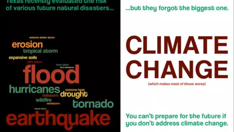

Texas is a state that fails to adequately consider how climate change will affect future natural disasters.
Every three years, states are required to submit hazard mitigation plans to the Federal Emergency Management Agency (FEMA). Hazard mitigation plans identify a wide range of natural disasters that individual states may face, like the ongoing drought that has gripped parts of Texas, the recent extreme flooding in Austin, as well as major tropical storms like Sandy, which last year battered a half-dozen states along the Northeastern coastline. In addition to identifying future risks from natural disasters, these plans also outline how states can prepare for and mitigate harm from such natural disasters and guide the use of federal, state, and local disaster funds.
In developing a State Hazard Mitigation Plan, states must consider the wide range of natural disasters they might have to respond to in the future. This forward thinking allows states and communities to anticipate problems and possibly avoid them, rather than simply respond to them.
Preparing for natural disasters can no longer be just an exercise in learning from the past. States must also undertake forward looking inquiries using new information on how climate change will affect the frequency and the severity of natural disasters and related changing weather patterns.
The Texas plan approved by FEMA in 2010 relied almost exclusively on historical data to anticipate future disaster scenarios. The state failed to take into account the latest scientific projections of longer and more intense droughts, more severe flooding, and increased extreme heat and other changes brought on by climate change. Until these plans use the best information available, communities in states like Texas will needlessly be at risk. The recently approved 2013 plan suffers from the same deficiencies.
In the 2010 plan, the Texas Department of Emergency Management addressed risks associated with 14 natural hazards. Of those 14 types of hazards, at least half are affected by climate change, including floods, hurricanes and tropical storms, drought, wildfires, coastal erosion, and extreme heat. Unfortunately, the Texas hazard mitigation plan does not consider the risks of climate change in any hazard profiles except for mentioning sea level rise in the coastal erosion section.
This analysis looks at specific sections of the state’s 2010 plan and critiques the state’s risk assessment for various types of natural disasters. In addition, this analysis presents examples of scientific information on climate impacts that Texas should factor into its future disaster preparedness plans. This information not only illustrates the increased future risk of natural disasters that Texas faces, but also illustrates the wealth of climate information that Texas should factor into its disaster preparedness plans, if it chose to.
It should be noted that Texas submitted its 2013 plan to FEMA for approval but it was not made available for public review. As such, our analysis had to be based on the 2010 plan. The state's 2013 plan was recently finalized, but suffers from the same deficiencies as the 2010 plan by failing to recognize the impact of climate change on the severity and frequency of natural disasters.
Drought
The hazard mitigation plan adopted in 2010 states that all of Texas is vulnerable to drought, citing historical drought events from 2007 to 2010. The plan states that drought caused roughly $11.65 million in crop damage (supra note pp. 59-60) from January 1, 2007 until June 30, 2010. Interestingly, this figure for crop damage is almost two orders of magnitude less than figures for crop losses given by the U.S. Department of Agriculture which reported $1.06 billion in crop insurance payments made to landowners in Texas between the years 2007-2010.
No mention is made in the plan’s risk assessment about the impacts of drought on municipal water supplies. The 2010 plan (p.61)ranks drought as a low priority risk and says droughts are possible, but not necessarily “probable” in the five years following 2010. Large parts of Texas were subsequently gripped by severe drought in 2011, 2012, and 2013. The plan does not reference rising temperatures, changes in precipitation and increasing evaporation expected from climate change and how these factors are likely to exacerbate the potential for future droughts in the state. The plan thus fails to assess expected future losses due to increasingly extreme drought disasters. All of these considerations are necessary criteria for evaluating future drought risks and impacts.
In short, the 2010 Texas plan seriously underestimated the risk of drought and the future role of climate change.
Climate information that could inform future plans in Texas
- Texas is already one of the driest states in the country, and it is likely to become drier in the future. As temperatures increase, soil moisture levels could decrease (p. 91) by about 5% to 20% by the year 2100. Texas could lose up to 12% of its average annual precipitation by 2085, under a high greenhouse gas emissions scenario.
- As the climate warms, the vast majority of watersheds in Texas are likely to experience an increased level of water stress, meaning that water demand will exceed water supply.
- In 2011, the hottest and driest summer on record in Texas ( led to drought conditions that resulted in over $7.5 billion in agricultural losses, including livestock and crops.
- Crop insurance payments attributable to drought in Texas totaled $2.3 billion for 2011 and 2012.
- Reduction in available ‘stored’ water is a serious concern following a number of years of drought. Several water supply reservoirs in Texas are now at less than 10% of capacity, including Lake Abilene (7.0%), Champion Creek (7.7%), E.V. Spence (4.8%), Electra (0.0%), J.B. Thomas (1.5%), Mackenzie (5.6%), Medina (4.3%), Palo Duro (5.8%), Twin Buttes (0.0%), and White River (0.0%).
Tropical Storms and Hurricanes
The Texas plan finds (supra note 1, at 49-52) that all coastal areas in the state are vulnerable to hurricanes and tropical storms but only references historical occurrences from 2007 to 2010. The plan fails to consider how rising sea levels and temperatures are likely to expand the area impacted by storm surges and associated flooding that accompany hurricanes.
Climate information that could inform future plans in Texas
- The effects of rising sea levels may exacerbate storm surges, leading to greater loss of life and property destruction during storm events. One recent study (p. 31) found that rising sea levels would result in storm surges in Corpus Christi that were between 0.2m – 0.5m (0.6 ft – 1.6 ft) higher by 2030 and 0.6m to 1.8m (2.0 ft– 5.9 ft) higher by 2080 than those experienced when Hurricane Carla struck near there in 1961.
- Texas specific information exists to gauge some of the financial risk associated with climate change. A recent study conducted by the World Bank illustrates the risks a storm might pose to coastal Texas, even if cities erect defenses that kept up with sea level rise. The World Bank study found that even if Houston erected defenses to handle sea level rise of 60 cm (23.6 inches), it would experience $9.05 billion in estimated flood losses if those defenses were breached.
- Recent experience with Hurricane Ike, which caused $24.9 billion in damages in 2008, further illustrates the vulnerabilities of Houston and other coastal communities in Texas.
Floods
The Texas hazard mitigation plan recognizes flooding caused by excessive rainfall as a risk, but it only references (pp. 44-46) historic precipitation runoff for the state and maps historic flooding events from 1960 to 2008. The Texas plan also relies on FEMA’s flood maps and Flood Insurance Study as a reference for estimating flooding risks, but for some coastal areas of Texas these maps are more than 20 years old.
Climate information that could inform future plans in Texas
- Although climate change is expected to reduce annual mean precipitation in Texas over the next century, it is also expected to lead to more extreme rainfall events, which contribute to local flooding. Parts of Texas can expect up to a 30% increase in extreme precipitation days by midcentury, defined as days receiving more than one inch of rainfall.
- A recent FEMA analysis shows that dozens of Texas counties can expect to see areas susceptible to flooding to increase in size between 30% and 60% by 2100.
- Texas’s reliance on FEMA’s flood risk maps means the state is relying on maps that do not factor in sea level rise and the increased risks of heavier and flash storms that contribute to flooding. FEMA is currently reviewing how best to factor these climate-related risks into future maps, but that work remains to be done.
- As sea levels rise, people and property in coastal areas of Texas are at risk of flooding and could be displaced.
Coastal erosion
Coastal erosion leads to loss of beach and shoreline, threatening homes, businesses, and highways. According to the current Texas plan (supra note 1, at 69), 64% of the Gulf shoreline is considered a critical erosion area, and 235 acres of Texas Gulf shoreline is lost annually to erosion. The plan does recognize (supra note 1, at 74) that climate change is contributing to rising sea levels and this will contribute to coastal erosion.
Climate information that could inform future plans in Texas
- Texas could lose 284 sq. km (109.7 sq. miles) of dry land and an additional 4,893 sq. km (1,889 sq. miles) of coastal wetlands if sea levels rise 1 meter (approximately 3 feet). The loss of coastal wetlands leaves the coastline vulnerable to increased erosion and eliminates a natural buffer to storm surges.
- In the Galveston area, relative sea levels have risen nearly 2 feet due to climate change and land subsidence.
Extreme heat
Extreme heat poses serious public health risks, with direct links to increased illnesses and premature deaths. The Texas hazard mitigation plan (pg. 102) states that all of Texas is vulnerable to extreme heat, and West Texas is the most vulnerable. However, the plan only references (pg. 102) a map of historical occurrences of extreme heat from 1980 to 2003, without acknowledging the effects of climate change on future extreme heat risks to public health.
Climate information that could inform future plans in Texas
- Heat extremes are expected to become even more frequent with climate change-the most recent National Climate Assessment projections show days over 95â°F increasing more than 25 days over the annual average in Texas by mid-century.
- Texas had 11 times more record-breaking high temperatures than record-breaking low temperatures in 2012.
- Average summer temperatures in Texas could be about 3.5-5.0° C hotter (6-9° F) by 2090, relative to the 1990s.
Conclusion
Due to its size and geography, Texas is faced with a wide array of climate impacts and vulnerabilities. Parts of the state will become drier and more prone to droughts and, while other parts of the state will see increased precipitation from intense storms which will likely to increase the risks of flooding. The state’s coastline is also vulnerable to rising sea levels, which will eventually inundate low-lying areas, further accelerating coastal erosion and making coastal flooding more likely due to storm surges.
Many climate change impacts are already being felt in Texas, and some cited above may not be fully realized for decades. But it is important that Texas begin preparing for those challenges today. The climate impacts described above are projections of average future conditions, but these impacts will not occur in a predictable, linear fashion. Each year, climate change subtly loads the dice in favor of larger storms, heat waves, prolonged drought, and other events. Texas cannot presume it has years or decades to prepare and act.
In developing a State Hazard Mitigation Plan, states are supposed to anticipate the wide range of natural disasters they might have to respond to in the future. Thinking ahead allows states and communities to anticipate problems and possibly avoid them, not just respond to them. Texas largely relies on historical data to gauge its risk from natural disasters. But as our climate warms, the weather related disasters of the past may no longer be representative of the risks Texas now faces and will face in the future.
In order to safeguard the lives, property, and economy of Texas it’s critically important that the state and FEMA work to assess how climate change will affect the frequency and severity of natural disasters. Only by conducting an assessment of climate risks can Texas and FEMA make proper use of scarce resources to prepare for the changing weather patterns and natural disasters of the future.