The Bureau of Land Management (BLM) has released a draft rule that would govern hydraulic fracturing ("fracking") of federally managed oil and gas resources. There are many reasons why it is essential that the BLM issue strong, protective new rules for fracking. Among them is the fact that this rule, once finalized, will apply not only to federal public lands (like national forests and lands managed by the BLM), but will also apply to private lands where federally-managed oil and gas resources lie beneath non-federal surface property – a legal situation termed “split estate.”
If you own the surface of your land, but do not own the rights to the oil and gas beneath your land, you are in a split estate situation (split estate arose historically because of the various homesteading acts, which encouraged development of the West). In this situation, the oil and gas rights take precedence over the surface owner's rights, meaning that drilling and fracking can occur right in someone's backyard, or on their ranch, without the landowner’s consent. So the BLM rule will apply to fracking in residential and agricultural areas, as well as on public wildlands. In fact, a BLM Montana State Office publication entitled “Do you really OWN the minerals under your land?” says: “There is a good chance if you purchase property in Montana (and many other areas in the Rocky Mountain West), you may not be getting ownership of as much of the property as you think you are.”
NRDC's GIS expert, Matthew McKinzie, just completed an analysis of how many acres in the U.S. are privately owned but in a split estate with federal oil and gas resources. He has also analyzed, to the extent possible with publicly available information, where these acres are. Below is Matthew's eye-opening analysis with four important maps:
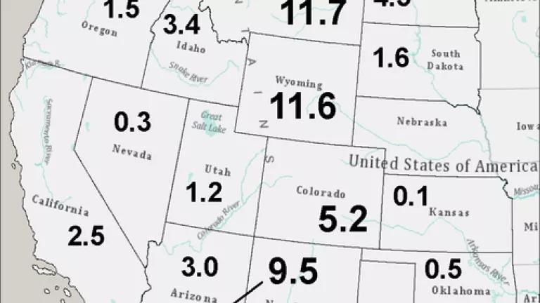
In total, the BLM estimates that 57.2 million acres in the United States are split estate where federally-owned minerals lie beneath private surface (this total number for federal minerals includes coal as well as minerals like uranium--in addition to oil and gas resources). This is an area roughly the size of Georgia.
Ninety percent of split estate lands fall within eight states west of the Mississippi – Montana (11.7 million acres), Wyoming (11.6 million acres), New Mexico (9.5 million acres), Colorado (5.2 million acres), North Dakota (4.5 million acres), Idaho (3.4 million acres), Arizona (3 million acres) and California (2.5 million acres).* In addition, 300,000 acres of split estate occur in states east of the Mississippi River. The first map below shows how many millions of acres of split estate occur within the western states (Nevada has comparatively fewer split estate lands simply because the federal government in fact has surface ownership over most of the state):
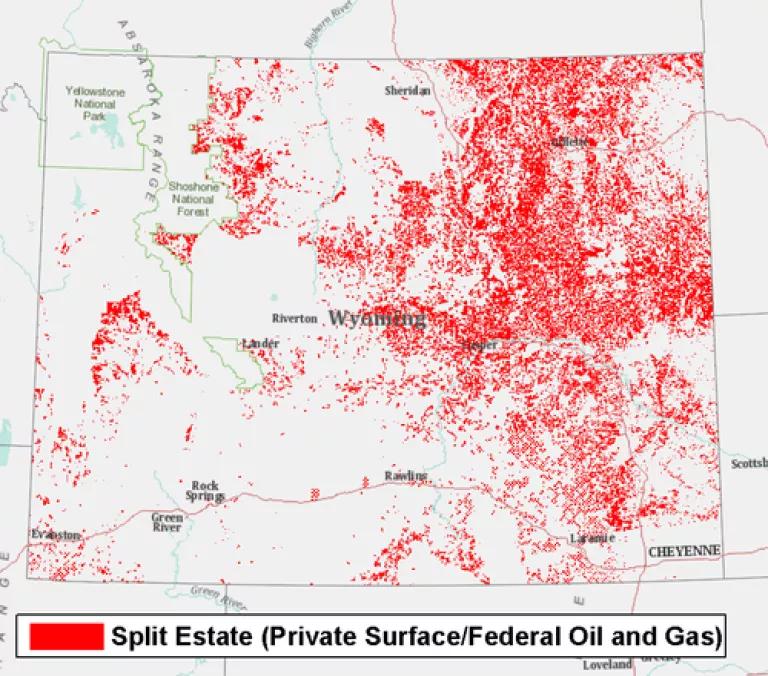
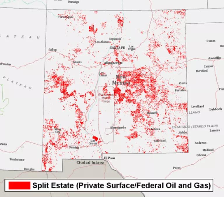
What is the detailed geography of split estate? The BLM provides Geographic Information Systems (GIS) data on both surface ownership and federal subsurface oil and gas rights for only a handful of western states. These two sets of GIS data can be used together to create a map of split estate, as shown in the next figures for Wyoming, Colorado and New Mexico.** These maps specifically show (in red) where there is private surface ownership and federal subsurface oil and gas rights (we excluded other types of federal mineral rights like exclusively federal coal rights in order to focus on fracking) – about 9.5 million acres in Wyoming, 4.7 million acres in Colorado, and 7.2 million acres in New Mexico. As can be seen in the figures, the split estate lands for Wyoming are predominantly a patchwork in the eastern half of the state and split estate is distributed throughout Colorado and New Mexico, and the federal oil and gas resources often overlap with developed areas where people may live and work. Thank you, Matthew, for these terrific maps:

*Data from BLM’s current public land statistics: http://www.blm.gov/public_land_statistics/index.htm
**Surface and mineral ownership digital map data from: the BLM-WY GIS data website – http://www.blm.gov/wy/st/en/resources/public_room/gis/datagis.html, the BLM-CO GIS data website – http://www.blm.gov/co/st/en/BLM_Programs/geographical_sciences/gis/metadata.html and from the BLM-NM GIS data website – http://www.blm.gov/nm/st/en/prog/more/geographic_sciences/spatial_data_metadata.html.