As Sea Level Rise Threatens Their Ancestral Village, a Louisiana Tribe Fights to Stay Put
They survived the BP oil disaster, Hurricane Katrina, and decades of industry spoiling their wetlands. Whatever their future holds, the people of Grand Bayou want to decide it for themselves.

Fire consumes the Deepwater Horizon oil rig in the Gulf of Mexico on April 22, 2010.
U.S. Coast Guard
Ten years ago, as news of the BP oil disaster reached Louisiana’s Grand Bayou Indian Village, Rosina Philippe dispatched her brother Maurice Phillips on a reconnaissance mission. Phillips pointed his flatboat toward the Gulf of Mexico and motored through a series of canals and inlets until he reached a fertile fishing ground called Bay Jimmy, eight miles from home. He returned with a passenger: a brown pelican, alive but slathered in petroleum.
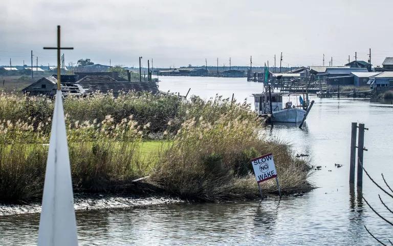
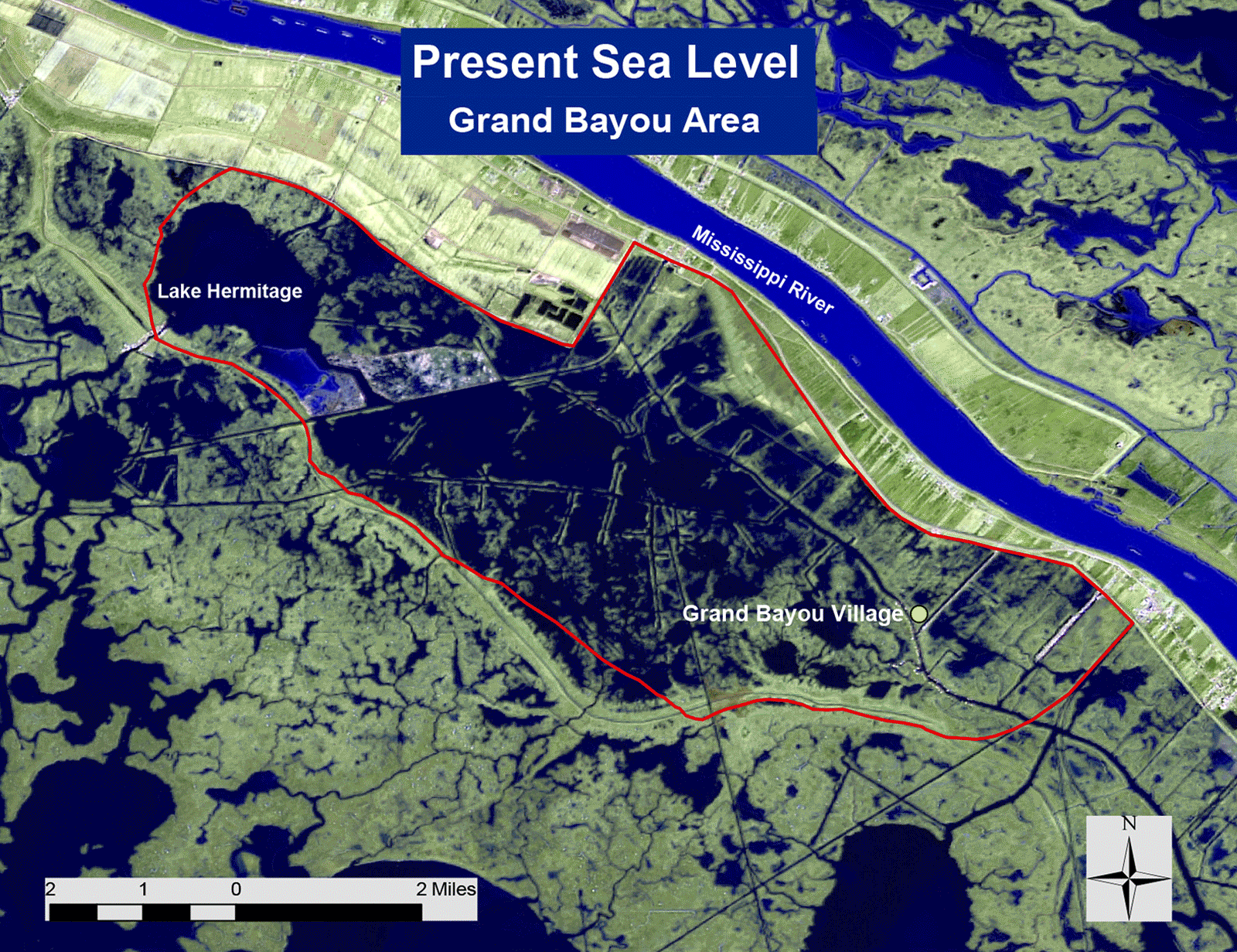
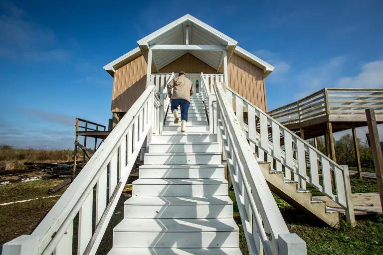
Philippe and her brother belong to the Atakapa-Ishak/Chawasha Tribe. They live in their ancestral village, an hour’s drive south of New Orleans near the town of Port Sulphur. Most of the tribe’s estimated 400 members live elsewhere, but a remnant remains in Grand Bayou, a community that has shrunk over the years as its land has slowly slipped into the surrounding waters. The village consists of 14 homes and a nondenominational church. Surrounded by water, most of the buildings sit atop wooden pilings, and there are no roads to connect them. The houses line the bayou and can be reached only by boat.
For generations, the Atakapa-Ishak/Chawasha have relied on the fertility of the Mississippi River Delta. They catch seafood and forage for wild celery, green onions, and a leafy green called morelle noire. They used to forage for persimmons, too. They trapped muskrats, packing the meat in salt and preserving it in oak barrels. They hunted for deer and rabbits—and still hunt ducks—and grew vegetables in large backyard gardens. In recent decades, however, these resources have contracted. The tribe has withstood one environmental assault after another, standing its ground in a disappearing wetland.
As they scrambled to save the pelican (which they later turned over to a wildlife rescue center), Phillips told his sister that he saw other oiled birds but could wrangle only that one onto his boat. What’s more, Bay Jimmy was covered in thick, gooey crude. Nearly two months after the April 2010 disaster, then governor Bobby Jindal visited the same bay and declared that BP’s oil was “killing the marsh.”
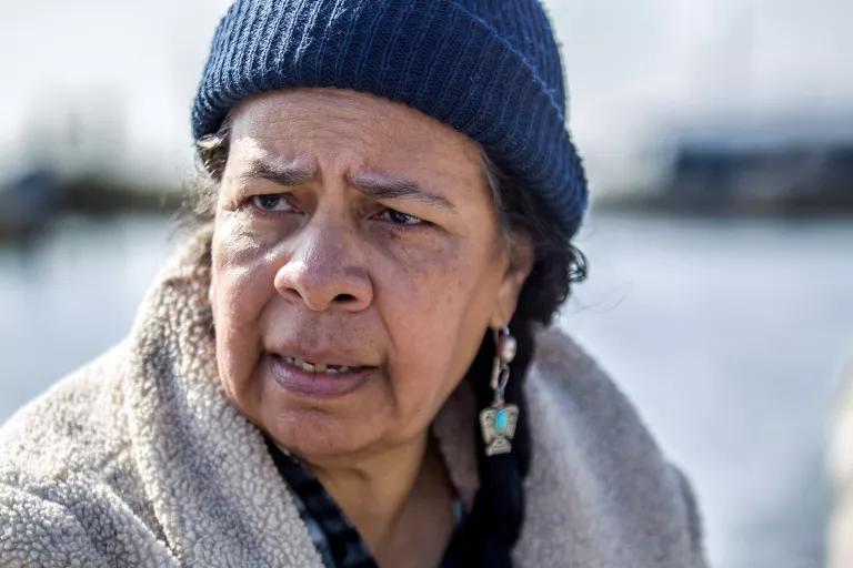
The Deepwater Horizon explosion and resulting 87-day oil spill proved catastrophic for Grand Bayou. The community had just rebuilt after Hurricane Katrina, which devastated the area in 2005, and residents had returned in time for the 2010 commercial shrimping season. “A lot of guys, what little bit of cash they had, they invested into making repairs on their boats because they envisioned the seafood to come,” says Philippe, a tribal elder. The springtime waters brimmed with shrimp. “So, it was almost like the anticipation of Christmas morning.”
Except that Christmas never came. The oil spewing from BP’s open well about 5,000 feet below the Gulf’s surface shut down the nearby fisheries for months. Grand Bayou’s fleet remained docked long after officials insisted that Gulf seafood posed no health risk. The fishermen didn’t agree. “As long as they believed that it was unsafe to eat,” Philippe says, “they refused to go out and catch it, even though they were in dire straits financially.”
Now, with the 10th anniversary of the explosion approaching next week, the tribe is clear on two points. First, the BP disaster cannot be viewed in a vacuum. It is part of a litany of stresses that Grand Bayou has survived for decades, including the loss of more than 5,000 acres of fertile Delta land. And, second: They have no plans to leave.
“We’re resilient,” says Carmalita Sylve, who grew up in Grand Bayou, moved to Colorado after Hurricane Katrina, and returned to a rebuilt home in 2009. From the tribe’s mainland headquarters, she gestures outside toward a grass-lined bank where boats dock and neighbors come to fish. “It’s like this grass out here. You smoosh it down, but you know what? It will come right back. And that’s how we are. You think that you’re going to just overcome us with the different ways. But we’ll adapt.”
Fateful Omissions
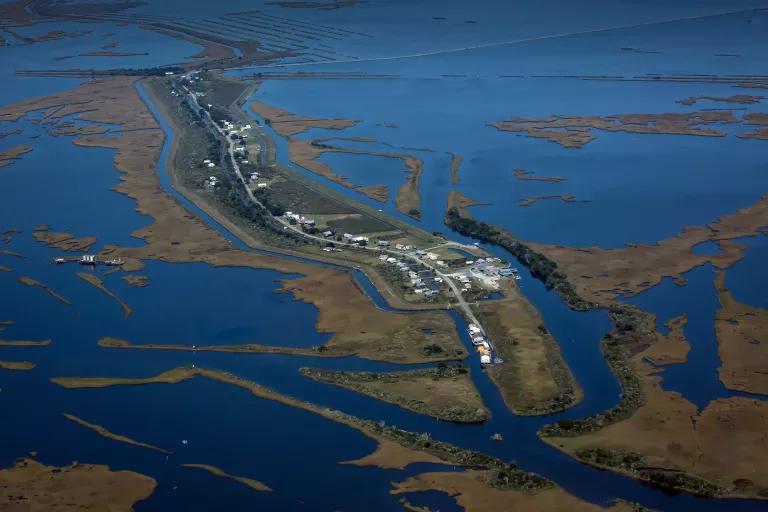
The threats faced by the Atakapa-Ishak/Chawasha reflect, and amplify, what’s happening in vulnerable communities all along the Louisiana Gulf Coast. Since the 1930s, about 2,000 square miles—more than 10 times the land area of sprawling New Orleans—have disappeared from the state’s coastline. Grand Bayou lies outside the protection of the state’s levee system. It lies outside the planning loop, too: The tribe was not formally consulted when the state developed its most recent master plan for coastal restoration.
That $50 billion plan, published in 2017, is essentially a detailed wish list. At its core are large engineering projects like pipelines to pump sediment into degraded wetlands in order to elevate the land and restore the marshes. “What is in the plan is not necessarily funded,” says Stuart Brown, who oversees the plan’s development at the Louisiana Coastal Protection and Restoration Authority (CPRA). Rather, he says, it’s a “prioritization effort.”
The master plan also lays out risk-reduction strategies for communities facing increased flooding. Depending on the projected flood levels and the type of building, it recommends one of three alternatives: floodproofing, elevation, or “voluntary acquisition.”
Nothing in the plan explicitly calls for the tribe’s, or anyone’s, relocation. But neither does it offer resources or a long-term vision for Grand Bayou to remain an intact village as the surrounding wetlands continue to erode. Members of the Atakapa-Ishak/Chawasha say they feel a tacit, and sometimes explicit, pressure to plan a future elsewhere.
That pressure, elders say, fails to consider the tribe’s connection to the bayou. It is so ancient, so sacred, that any discussion of resettlement evokes comparisons to the Trail of Tears. Grand Bayou predates the oil companies and the levee builders; predates the refineries and borrow pits that line the nearby highway; predates Louisiana statehood. The prospect of leaving feels, to them, like cultural erasure.
Place Markers
Last year a group of scientists, public officials, lawyers, and coastal residents met in New York City at a conference organized by Columbia University’s Earth Institute to discuss “managed retreat,” an idea that has gained traction in planning circles. The notion is that life along certain coastlines has grown untenable and that orderly relocation is the logical solution.
A handful of U.S. communities have already confronted the decision. After the 1993 Mississippi River floods inundated Valmeyer, Illinois, residents voted to rebuild their town 1.5 miles to the east and 400 feet up a bluff. Shishmaref, Alaska, an Iñpuiat village on a barrier island that is eroding from melting permafrost and sea ice, is currently waiting on federal funds to move to the mainland. (According to PRI’s The World, climate-change denialism has held up the money.)
Closer to home, the planned resettlement of Louisiana’s Isle de Jean Charles Biloxi-Chitimacha-Choctaw Tribe, whose ancestral island has nearly disappeared, has been mired in a conflict over tribal sovereignty. The tribe’s leaders say they’re not being treated as co-collaborators—in fact, they learned about the state’s purchase of land for resettlement by reading a press release. State officials say they have tried to work with those leaders but are “not in a legal position” to acknowledge the sovereignty of a tribe that is not federally recognized.
Valmeyer, Shishmaref, and Isle de Jean Charles could be the vanguard of something bigger. The U.S. government’s 2018 National Climate Assessment envisioned the future relocation of “millions of people” as retreat from rising seas becomes an “unavoidable option.”
“That’s what the people in Miami are facing. That’s what I’m facing in New Orleans,” says Mark Davis, director of the Tulane Institute on Water Resources Law and Policy. Climate change, he says, will make some places uninhabitable, even if residents want to stay. “Sooner or later, they are going to be dealt a hand they cannot play.”
Among those attending the Columbia conference were representatives of four Louisiana tribes, who spoke together on a panel. Rosina Philippe was among them. Fewer phrases pique the Grand Bayou elder faster than “managed retreat.” Given the arc of U.S. history, she worries that it’s the rebranding of an old policy: making life-altering decisions about communities without their participation or consent.
“They’re couching it in such agreeable terms. ‘Managed retreat.’ Well, managed by whom?” Philippe asks. “We’ve seen so many instances of other people looking at indigenous populations and deciding they should go there, or they can’t go there, and thinking that they were doing the right thing. And we learn through the historic context that it was to the tribe’s detriment. But yet they continue to not learn from the past mistakes.”
To understand the depth of this sentiment, one must understand the value of place in Grand Bayou, where money is scarce but biological and social capital are ample. That sense of abundance stems from an era, within the memory of elders, when the village had dozens of households and looked very different.
“You see water back here, but all of this was ground,” says Carmalita Sylve.
“High ground,” says Philippe.
“You could walk probably just about almost to the Gulf of Mexico,” says Sylve.
When Sylve and Philippe were children, houses had yards, and there was enough land to raise goats and plant peach orchards. The wetlands provided nurseries for fish and shellfish. Add to that the game and foraged plants, and there was little reason to visit the mainland other than for staples like rice and flour.
Here, self-sufficiency meant interdependence. If someone’s bulkhead had loose planks, there would be an announcement at one of the tribe’s regular gatherings or from the pulpit at church. Neighbors would then make plans to fix it. Without ready access to physicians, even health care was a communal effort. The tribe had traiteurs, traditional healers, who used medicinal plants from the marshlands. Older residents talk about “making the veillée,” or holding vigil, at the home of sick neighbors: cooking, cleaning, and brewing coffee so the immediate relatives didn’t have to.
With a social fabric so deeply tied to the wetlands, it’s hard to separate identity from geography. “It’s like we’ve incorporated our very DNA into what’s around us in the land, the air, the water, the other life forms that share the space with us,” says Philippe. “We see ourselves as having our pail full because we have the history of cohabitation, the history of the knowledge of place, of belonging.” Leaving, she says, would upend that relationship. “We would be somewhere else, in a different place with an empty pail. And that’s a feeling almost like a death, like a bereftness.”
The fact that most of the tribe has already left doesn’t diminish that feeling. Loved ones return and pack their relatives’ houses for holidays, summer vacations, and biennial tribal reunions. Some own land in the village. “My grandkids, even though they were born in Tennessee, they claim Grand Bayou as their heritage,” says Geraldine Phillips Ancar, the village’s oldest resident. Ancar, who is in her eighties, co-pastors Grand Bayou’s Light Tabernacle Church with her husband, Bennie. When their youngest grandson, a U.S. Marine, comes to visit, he spends entire days exploring and photographing the wetlands.
Those who stay feel responsible for maintaining the village for the diaspora. “We’re like place markers on the table,” Philippe says, “waiting for everybody else to come and dine.”
Defeats of Engineering
About a decade ago, when he was working on his Ph.D. at the University of New Orleans, Matthew Bethel collaborated with Grand Bayou residents to map the 27-square-mile “livelihood base” where they fished, trapped, and hunted. He studied aerial photos and quantified the landscape changes over four decades.
Bethel calculated a net land loss of 5,449 acres—the shedding of vast productive habitat even before the BP spill soiled so much of what remained. In 1968 there were 2.62 land acres for every water acre. By 2009 that had fallen to 0.48 land acres. Bethel, now the associate executive director of research at Louisiana Sea Grant, published his findings in 2011 in the Journal of Coastal Research.
These losses, all along the Louisiana Gulf Coast, are the cumulative byproduct of humanity’s attempts to engineer the land. Starting in the 1930s, the state’s oil and gas industry cut 10,000 miles of canals into the Mississippi River Delta to transport drilling equipment and lay pipelines. Scientists say the canals destroy wetlands by funneling saltwater into freshwater marshes. That, in turn, kills the freshwater plants whose roots hold the land together. The “spoil banks,” piles of dredged material that run parallel to the canals, also interfere with the natural water flow. In addition, the leveeing of the Mississippi River, particularly after the Great Flood of 1927, has blocked sediment-rich water from overtopping the riverbank during floods. The levees impede the natural process of rebuilding wetlands as they subside, or sink.
There are other causes of land loss, too, including oil from the BP spill, which harmed root systems, and hurricanes. As the climate continues to change, scientists expect sea level rise to increase exponentially, compounding the problem. According to the state’s master plan, sea level rise on the Louisiana Gulf Coast could exceed six feet by 2100.
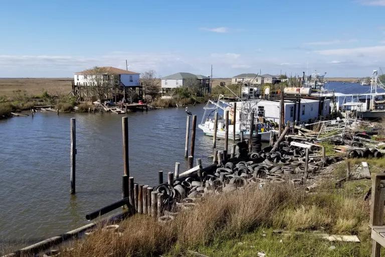
In Grand Bayou, Philippe says the phrase “land loss” underplays the damage. “That’s habitat loss,” she says. “Those are the nursery for the young shrimp and for the animals around us.” The wetlands also offer protection from storms. As they disappear, communities become more vulnerable. Some people leave for safer harbors.
When Hurricane Katrina hit, Grand Bayou residents hunkered down in boats near the small city of Belle Chasse. They stayed for months, cooking and doing laundry together. It took almost five years to reconstruct their homes with the help of church and community-development groups. By the time returning became an option, some had built new lives on the mainland.
“My husband would like to move back,” says Philippe’s younger sister, LaDonna Sylve, an artist visiting Grand Bayou from her home in Belle Chasse. “But my grandbabies are right there”—in Belle Chasse—“and they’re a big part of my life. I want to be near them, to nurture them and teach them some of the ways that we had here.”
Feats of Resilience
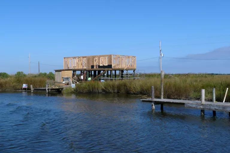
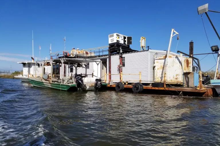
Since their return to Grand Bayou in 2010, the Atakapa-Ishak/Chawasha Tribe has experimented with adaptations they hope will help them survive climate change, rising waters, and hurricanes.
They’ve turned a barge into a floating home. They’ve built portable gardens in canoes and small boats called pirogues. They’re working with the nonprofit Coalition to Restore Coastal Louisiana to protect sacred sites with reefs built from oyster shells recycled from New Orleans restaurants. Such reefs not only protect against erosion but also create new oyster habitat.
The tribe has also advocated for a low-tech coastal restoration project: backfilling those canals that were dug by oil and gas companies. In a 2018 study, coastal scientists R. Eugene Turner and Giovanna McClenachan concluded that filling the canals with spoil-bank material “could be a dramatically cost-effective and proven long-term strategy” for reversing land loss.
The scientists estimated that backfilling all the canals would cost about $335 million, less than 1 percent of the state’s $50 billion coastal master plan. “It’s really cheap. You can’t beat it,” says Turner, a professor of oceanography and coastal sciences at Louisiana State University. And yet, “if you go through the master plan and look for the word backfilling, you won’t find it.” (This is true.)
Brown, the CPRA official, agrees that backfilling works. But he also calls Turner’s paper “a little bit hyperbolic” and says that the state’s plan focuses on higher-impact projects.
The tribe is particularly worried about one of those projects: the $1 billion Mid-Barataria Diversion, which would add a series of gates to a Mississippi River levee 15 miles from Grand Bayou. Those gates would allow sediment and freshwater through, nourishing the wetlands and building an estimated 30,000 acres. According to a 2017 study, however, the diversion could increase flooding in Grand Bayou as it enhances wetlands elsewhere. CPRA’s Brown calls flooding a “reasonable concern” and says the state is preparing an analysis.
Beyond specific projects, Grand Bayou residents see a bigger problem with Louisiana’s master plan: When it was last updated, in 2017, they were never officially consulted. “People are making plans for our lives,” says Philippe. “And they’re not letting us self-determine and be a part of that conversation.” While individual members have met with CPRA to discuss specific concerns, all the tribe can do, she says, is speak at public meetings and submit written comments. These are inefficient ways to address existential policy concerns.
The coastal agency did convene a “community focus group” as it developed the 2017 plan, which included representatives from 11 organizations. They included three tribes that the state of Louisiana officially recognizes, though the federal government does not. (Three individual members of the focus group described it as perfunctory. Sandy Ha Nguyen, executive director of Coastal Communities Consulting, a nonprofit serving fishing families and related small businesses, called it a “waste of time.”) The Atakapa-Ishak/Chawasha, who lack even state recognition, were not invited.
CPRA’s Brown acknowledges this communication shortfall. “I think that is a fair complaint,” he says. “We did have meetings with several tribes. Grand Bayou is not on that list.” As the state prepares to revise its master plan in 2023, “we are trying to be more intentional about how we reach out—not only to the tribe but to many folks who have not been involved in the process.”
Even open communication has limits, though. Coastal planning involves large state and federal bureaucracies with rigid policy options. Creative solutions like the ones Grand Bayou wants to develop—houses on barges, for example—are typically off the table.
“Nobody’s talked to them about innovative ways to stay,” says Cyn Sarthou, executive director of Healthy Gulf, a New Orleans–based nonprofit. “It’s just ‘You have to fit into our model, or you have to leave.’”
Brown concedes that the state can only consider conventional solutions, because government funding comes with strings. “They are 100 percent correct that programs that fund that work are not going to be nimble,” he says. “That’s a very legitimate criticism.” But he reiterates that no one is forcing the Atakapa-Ishak/Chawasha to relocate. “We don’t have a forever solution, but we don’t believe it’s unreasonable that Grand Bayou can continue to exist for 30 or 50 years,” he says. (The 25-year flood maps are ambiguous, but Grand Bayou appears to straddle the line between elevation and voluntary acquisition.) Any longer is beyond the state’s planning horizon, Brown notes, and the latter part of the century is likely to bring more land loss, sea level rise, and storm surge.
Coexistence
Grand Bayou’s biggest building is Light Tabernacle Church. Its size mirrors the importance of religious life here. “People still have that desire to put God first in their life,” says Ancar, the pastor. Inside is one of the tribe’s greatest treasures: a set of stained-glass windows depicting life on the bayou. There are images of shrimp boats, a burial site, and wildlife like a crab and an alligator, plus a large, abstract triptych suggesting a sunset over the marsh.
The story behind the stained glass tells a bigger story about place and resilience. The windows were produced by stained-glass artist Mary White, whose father, geographer Gilbert F. White, was the founder of the University of Colorado’s Natural Hazards Center. Until his death in 2006, he believed that behavioral changes, rather than building ever more levees and dams, were the best ways for humans to coexist with flooding.
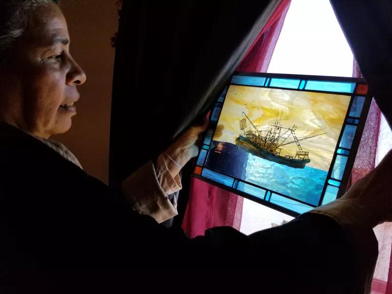
The Natural Hazards Center convenes an annual workshop. At one of these events, a Grand Bayou resident named Paul Sylve approached the pioneering geographer and serenaded him in Louisiana French as a way of honoring his work. Mary White witnessed this tribute to her father and was moved. After Hurricane Katrina, she offered to craft the windows of the new church under construction. Grand Bayou residents provided drawings and photographs, and three young women from the tribe traveled west to help with the design.
Traditional built-in stained glass made no sense for the village; the next hurricane could level the church. The windows needed a bayou-appropriate adjustment. “What do you do with your treasure if you know that you’re housing it in an impermanent structure?” says Philippe. “You make it movable.” That’s what White created. The smaller images hang in front of the windows but are not permanently attached. The nine-foot-wide triptych is set into a light box over the pulpit and can be detached in sections.
The removable windows, which depict the tribe’s deep roots, embody Grand Bayou’s two competing realities: The tribe intends to stay. And, true to Gilbert White’s message, it recognizes that fragile landscapes require adaptation.
This is nothing new, Philippe says. Since her grandparents’ days, the tribe has adopted new home designs, new clothing, new motorized boats. Philippe knows that other communities are thinking about how to coexist with coastal erosion. “Those designs exist. We just need to find them and incorporate them in the new norm,” she says. “We intend to exhaust every adaptation designed in our quest to stay.”
This article was originally published on onEarth, which is no longer in publication. onEarth was founded in 1979 as the Amicus Journal, an independent magazine of thought and opinion on the environment. All opinions expressed are those of the authors and do not necessarily reflect the policies or positions of NRDC. This article is available for online republication by news media outlets or nonprofits under these conditions: The writer(s) must be credited with a byline; you must note prominently that the article was originally published by NRDC.org and link to the original; the article cannot be edited (beyond simple things such grammar); you can’t resell the article in any form or grant republishing rights to other outlets; you can’t republish our material wholesale or automatically—you need to select articles individually; you can’t republish the photos or graphics on our site without specific permission; you should drop us a note to let us know when you’ve used one of our articles.
What Will It Take to Tackle Water Scarcity on the Navajo Nation?
In Planning for Climate Change, Native Americans Draw on the Past
Colorado River Basin Tribes Address a Historic Drought—and Their Water Rights—Head-On