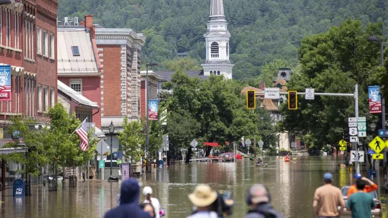
Pedestrians and kayakers navigate a flooded Main St. in Montpelier, Vermont, on July 11, 2023.
U.S. Army National Guard
Flooding in Vermont has once again exposed serious weaknesses in the state and federal policies that govern floodplain development and ensure that information is provided to people about the risks of flooding.
Because Vermont and FEMA’s flood policies fail to anticipate and account for climate change, more people’s homes are flooding, the amount of damage may be more severe than in years past, and the recovery time will be a lot longer. The state and FEMA need to act now with stronger flooding policies so the next flood won’t be so devastating.
Lax building codes, outdated flood maps, and Vermont’s lack of required transparency to renters and home buyers about home flood risks all contribute to making this flood into a major disaster. Another issue that will complicate people’s recovery from these events is how few people in the state carry flood insurance coverage.
Flood maps are out of date
Some towns that have been impacted by flooding, like Montpelier and Waterbury, are relying on flood maps that are 10 years old – and these are among the most current flood maps FEMA has produced anywhere in the state. Most other communities are relying on maps from 2007-2008, while parts of rural Vermont haven’t had new flood maps since the 1980’s or 1970’s, in some cases.
Vermont isn’t unique. Outdated flood maps are a national problem that needs to be fixed. FEMA’s flood maps are oft-criticized for being out of date, and it can take many years for the agency to release new ones.
Moreover, FEMA’s flood maps fail to tell you what your flood risk will be in the future, or how climate change is already contributing to rising flood risks. That’s because they are based exclusively on historical storms and past rainfall data. FEMA flood maps do not take into account the effects of climate change.
In Vermont, that means flood maps do not account for the increased likelihood of a storm like the one that brought flooding last week, or like 2011’s Hurricane Irene. And in coastal areas, FEMA’s flood maps fail to account for sea-level rise, which is a dangerous omission.
As a result, Vermonters are making decisions about where it’s safe to build based on flood maps that likely under-represent the true risk of flooding. People who constructed buildings in areas that FEMA maps say are at low risk for flooding may have been surprised to be flooded last week. This shortcoming is dangerous in a state like Vermont, where population centers may be in constricted river valleys where the potential for flooding is higher to begin with.
Vermont Gets an “F” on Flood Disclosure
The state experienced its last major flood disaster in 2011, when the remnants of Hurricane Irene swept through. If you bought or rented a home in Vermont since that storm, you were probably not told about past flood damages because Vermont does not require that sellers or landlords of properties disclose such information. You may have unknowingly bought a home with mold issues, damaged wiring, or an increased risk of getting flooded again. The State of Vermont should want you to know that before you buy, but the state does not require such information to be disclosed to a homebuyer or renter.
Vermont received a failing grade from NRDC and Columbia Law School for its failure to require disclosure of past flood damages, legal requirements to purchase flood insurance, and other flood risk information. FEMA’s own analysis of state flood disclosure requirements found that Vermont earned ZERO out of ten possible points. The Vermont Association of Realtors has a voluntary disclosure form that asks sellers to disclose some flooding information, but the form is completely voluntary.
Because of this lack of disclosure, homebuyers are kept in the dark about a home’s flood history. The result is people are buying and moving into homes, only to find out later about the flooding problems that they also purchased.
Vermont’s Building Codes Are Not Prepared for Climate Change
According to FEMA’s Building Sciences Division, Vermont’s building codes are among the weakest in the nation, allowing buildings to be constructed that are not as resilient to floods and other hazards as other states require.
Vermont’s building codes are also out of date. The latest version mostly conforms to the 2015 International Building Code (2015 IBC), which doesn’t cover single family homes, but does cover commercial properties, office buildings, and multi-family residences and apartment buildings. The state also stripped out most of the 2015 IBC’s requirements to use more flood resilient construction techniques.
Vermont is among the states without a statewide residential building code. As a result, each township and municipality adopts its codes independent of one another. This approach can often result in a “race to the bottom” as communities may cave-in to developers that want to keep profits high and may be less concerned about the long-term safety of the home.
Lack of Flood Insurance Coverage
According to data from FEMA, only 3,060 properties (2,518 residential homes and 512 non-residential properties) in Vermont are covered under the National Flood Insurance Program. That’s just under 1 percent of the households in the state.
Federal disaster aid is available to assist families and communities with the recovery. But federal disaster aid grants are relatively small compared to what they would receive from a flood insurance claim. A typical Individual Assistance grant from FEMA is about $3,000 while the average flood insurance damage claim is about $66,000 and will cover most repairs and the loss of a home’s contents.
Where do we go from here?
While the problems above are serious and leave many in harm’s way, these are solvable problems.
The State of Vermont can do a lot to help itself.
- The Vermont General Assembly should pass legislation to ensure that home buyers and renters are fully informed about a home’s past flood damages and potential for future flooding, as well as whether they are legally required to purchase flood insurance. New York and New Jersey both passed similar legislation over the past two years.
- The state should adopt the latest version of the latest International Building Code and, this time, NOT delete the provisions that ensure the use of flood resilient construction techniques. It could also adopt statewide the International Residential Code, which includes requirements to elevate single-family homes that are in the floodplain and use other techniques to safeguard homes against flood damages.
And FEMA can do a lot to help Vermont – and the entire nation.
- One of the most important and timely things FEMA could do is update its minimum land use and building code standards. Under the National Flood Insurance Program (NFIP), FEMA established minimum standards that serve as the floor for all building codes and zoning ordinances across the nation, or at least the more than 22,000 states, territories, and communities that participate in the NFIP.
FEMA has not updated these standards since the mid-1970s! It’s time to bring the floodplain development standards out of the 1970s and into the era of climate change. In response to a petition for rulemaking filed in 2021 by NRDC and the Association of State Floodplain Managers, FEMA is now working on this. But with each passing flood disaster, the need for updated standards grows. As part of that, FEMA could also require states and communities to have good flood disclosure policies on the books, as a condition of participating in the National Flood Insurance Program. Or Congress could direct FEMA to do that in legislation, which NRDC would support. - FEMA needs to begin including future climate impacts on its flood maps. In 2012, Congress directed FEMA to begin incorporating sea level rise, the potential for future extreme weather events, and climate impacts into its flood maps. But FEMA has failed to do so. Because flood maps are used to inform where to build and how to build, it’s critically important to know what flood risks are going to be in the future, not the past.
Producing up-to-date, climate-informed flood maps would better inform communities about their true flood risk and would increase the number of households who are legally required to maintain flood insurance coverage, which would help address Vermont’s under-insurance problem (see above). NRDC and the Association of State Floodplain Managers also petitioned FEMA to finally conform to this legal requirement.
Related Blogs

From a Whisper to a Murmur to a Chorus: It’s Time to Make Polluters Pay for the Climate Crisis

Growing Nationwide Trend of States Requiring Flood Disclosure