Finding Lead Water Pipes: New NRDC Map Shows the Hot Spots in Every State
Federal and state governments acknowledge the widespread presence of lead pipes throughout the country—NRDC’s new map reveals where they are. The EPA, states, and cities must act now to solve this problem.

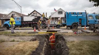
A Cabo Construction Corp. crew working around a ditch dug during replacement of a lead service line outside a home in the West Roseland neighborhood of Chicago
Vanessa Bly Photography
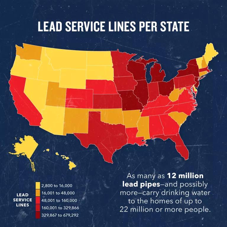
Our new map, based on U.S. Environmental Protection Agency (EPA) survey data recently released after NRDC submitted a Freedom of Information Act request, shows visually where our governments and utilities have found dangerous lead water service lines (and where they still do not know the pipe materials). This matters because in order to require removal of these lead pipes, as the EPA has promised, we have to know where they are. We now also have the chance to target the largest-ever pot of $15 billion in federal funds to replace many pipes, which were provided to address this problem, toward the communities that need it most.
The EPA data displayed in the map are being used to allocate billions of dollars in federal funds to states, based on how many lead pipes they have reported. The results of the EPA survey are sobering. In a new level of detail, we see a pervasive problem with cities and towns, big and small, across the country that have documented where people are drinking through what amounts to a lead straw, and where we do not even know the pipe materials. This is the image of a nationwide lead pipe crisis, as understood by our governments and utilities, and it is a striking call to action. This problem should not be a surprise. Generations ago, governments and utilities often required or encouraged and approved lead pipes, despite warnings from medical experts about the health threats they pose. Newer technologies, such as an AI-generated BlueConduit map, show that the extent of this problem is significant. These resources—old and new—underscore the importance of immediate EPA action.
Our new map is based upon lead pipe data reported by the EPA earlier in 2024, using survey data from thousands of water systems and states, as discussed below. There is probably substantial undercounting of lead pipes in many cases. Some highlights from the map include:
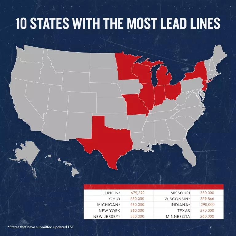
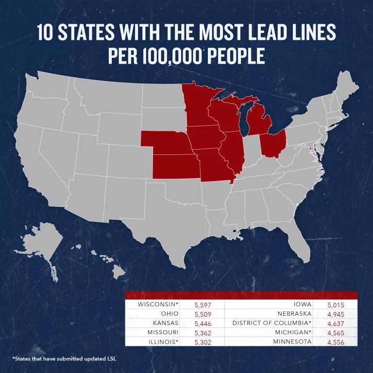
- Lead pipes occur in all 50 states, but some states have a disproportionate problem. These include Illinois, Ohio, New York, New Jersey, Wisconsin, Pennsylvania, and Florida, which are especially heavy hit. Other states, including North Carolina, Michigan, Georgia, Indiana, and Louisiana, also are among the states with the most reported lead pipes.
- Several cities report massive numbers of pipes with lead, including Chicago (387,000), Cleveland (235,000), New York City (112,000), Detroit (80,000), Milwaukee (74,000), Denver (64,000), St. Louis (63,000), Indianapolis (55,000), Minneapolis (49,000), Buffalo, New York (40,000), Cocoa, Florida (37,000), Washington Suburban Sanitary Commission (WSSC) Water in Maryland (36,000), Atlanta (31,000), Pittsburgh, Pennsylvania (29,000), and Philadelphia (25,000). As noted earlier, some of these cities (like New York) have large numbers of service lines of unknown material (“unknowns”) that may be lead, so these are likely underestimates for most cities. The number of unknowns is listed for each city, where reported.
- Some cities not previously widely recognized as having a lead problem have surprisingly high numbers of lead service lines. These include Cocoa, Florida (37,000), Northern Kentucky Water District (28,000), Conway, Arkansas (27,000), and Pasco County Utilities-Pasco County Regional Water System (PCUD-Pasco County Regional PWS) in Florida (24,000). There are several other surprises, including Fort Lauderdale, Florida (23,000), Memphis (20,000), and Winston-Salem, North Carolina (13,000).
- The top 30 cities with the most reported service lines containing lead are listed in Table 1 below. However, these numbers will change as more lead lines are discovered in these and other cities.
NOTE: This map is best viewed on a desktop/laptop/tablet; on mobile, the map is best viewed in Chrome.
National map of lead service lines is based on new EPA data and reveals the extent of the problem
The EPA’s 2024 analysis of its survey results from thousands of water utilities and state officials estimates that about 9.2 million lead service lines are in use. But until now, we generally haven’t known which water systems they are in and which communities are most impacted. When the EPA updated its lead pipe survey earlier in 2024, NRDC requested the underlying data using the Freedom of Information Act, and the EPA publicly released some of the data it had collected. The EPA’s Inspector General has recently criticized the agency for failing to effectively verify the accuracy of some of these data that were submitted by utilities and state officials. Still, the EPA’s survey provides the most comprehensive and useful nationwide information available to date about the presence of lead pipes in communities nationwide. Some of the state data (such as for Illinois and Michigan) are a result of detailed state inventory requirements and are likely to be more reliable than the data for other states (such as Florida) that have done little to complete a detailed statewide lead pipe inventory.
Learn More: Lead in Water


Despite its limitations, the data presented in our new national map provide the public with an early glimpse into how many of these lead pipes may exist in their communities. They also give insight into how the EPA is disseminating funding for lead pipe replacement, which is based on the data underlying this map.
The widespread problem of service lines with “unknown materials”
One important finding from these data is that there are enormous numbers of service lines marked as “unknown materials” by their water utilities, which could easily be or contain lead. We include in our map a layer that highlights the number of service lines of unknown material that each water system is estimated to have.
That so many water utilities have failed to inventory the lead pipes they have and where they are is deeply problematic. It highlights how multiple states and utilities have failed to make identifying and removing lead pipes that may threaten the health of their consumers a priority. It also may be a violation of federal rules in many cases. Under the 1991 EPA Lead and Copper Rule, utilities were required to complete a “materials evaluation” of their service lines. This was supposed to identify homes served by lead service lines for monitoring. If the water system exceeded the lead action level of 15 parts per billion of lead, the system was required to identify lead service lines across its entire system (see 40 C.F.R. §§141.84(b)(1) and 141.86(a) as in effect prior to 2024). Literally thousands of water systems have exceeded the lead action level since 1991, so they all should have identified their lead service lines years ago. Regrettably, this requirement apparently was not enforced, and several water systems have never identified where they have lead service lines.
Under the current Lead and Copper Rule Revisions, water utilities are supposed to submit to their states an initial inventory of their service lines by October 2024, identifying lead pipes in their systems. The inventory is also supposed to identify galvanized pipes that are or were ever downstream of a lead pipe. At some point in the future, there will be additional information available on both known and suspected lead pipes, and gradually, the number of service lines of unknown material will be reduced as utilities investigate where they have lead pipes.
The EPA says it will release its new Lead and Copper Rule Improvements by October 16, 2024, and that it will require most lead pipes to be removed within 10 years. Under that rule, the agency should finalize a strengthened inventory and universal 10-year lead pipe removal requirement at the utilities’ expense. To protect tens of millions of people from lead-contaminated drinking water, the nation needs a strong EPA rule that requires full replacement of all lead service lines within the next decade. And states, cities, and utilities should work with communities to follow the science and remove those pipes as quickly, safely, and equitably as possible.
Published July 8, 2021
Lead service lines—the pipes that carry water from the water main under the street to residences—have long been recognized as the primary contributor of lead in drinking water (we’ll call them lead pipes for simplicity’s sake). After conducting a survey of these lead pipes in the United States, NRDC estimates that there is a range of 9.7 million to 12.8 million pipes that are, or may be, lead, spread across all 50 states, including those that claim to have none. Unfortunately, given the lack of accurate state-provided data, this already shocking number could be a low estimate, and the associated health risks are enormous.
In an effort to characterize the scope and geographic reach of the problem, NRDC requested estimates of total lead water pipes from all 50 states and Washington, D.C. Just 10 states (AK, CA, CO, CT, IL, IN, MI, NJ, OR, WI) and the District of Columbia were able to provide us with statewide lead pipe estimates. After multiple follow-ups, 23 states (AL, AZ, DE, FL, ID, IA, LA, ME, MD, MT, NC, ND, NH, NM, NV, NY, OH, PA, SD, TN, TX, UT, WV) informed us that they do not track the number of lead pipes and could not provide us with those estimates. A few states (GA, MA, MO) reported that they are in the middle of surveying their lead pipes. Several states (AR, KS, KY, MS, NE, OK, RI, SC, VT, WY) failed to respond, despite at least three requests for these data. Four states (HI, MN, VA, WA) could provide data for only part of the state, which rendered it unusable for survey purposes.
This lack of data is concerning for multiple reasons. The U.S. Environmental Protection Agency (EPA) issued the Lead and Copper Rule, which set health standards for lead and copper in drinking water 30 years ago in 1991, yet most states do not have data on lead water pipes in their state, making it unlikely that they have been able to adhere to these health standards during that time. Additionally, in 2018, Congress required that the EPA develop an estimated number of lead pipes and the cost to replace them for each state by 2022. (See Safe Drinking Water Act Section 1452(h)(2)). The EPA is required to obtain these data from the states as part of its 2022 quadrennial “needs survey” for the Drinking Water State Revolving Fund (DWSRF). The DWSRF provides grants to states to pay for drinking water infrastructure; a few states have used a small amount of these funds for lead service line replacements. It is troubling that so few states have made the effort to estimate the number of their lead pipes in the face of the looming 2022 statutory deadline.
For those states that did not provide estimates, we relied upon a water industry self-survey from 2016 that the U.S. Government Accountability Office has noted provides “lower-bound” estimates. Combining the state-provided estimates with the 2016 water industry self-survey, we estimate that there are about 6.2 million known lead water pipes, plus 3.5 million to as many as 6.6 million service lines that are of “unknown” material but may be lead, for a total of 12.8 million pipes that are known to be lead or may be lead. However, because unknown pipes were only reported to us by six states (CA, IL, IN, MI, NJ, WI) and Washington, D.C., it is possible that even more unknown pipes exist and may be lead. There is no way to know without additional data collection how many of these unknowns are lead, but we know that previous pipe studies likely provided “lower bound” estimates due to data limitations. Put simply, the best guess is that the number of lead pipes is likely to go up from earlier industry estimates.
Our survey also revealed that lead water pipes are likely in use in all 50 states as well as in D.C. Alaska and Oregon state officials claimed to us that they have none, but the 2016 water industry self-survey estimated that Alaska had about 3,800 lead pipes, and Oregon had about 14,000 lead pipes.
When states do more detailed reviews of the number of lead pipes, our survey shows that previous industry guesstimates can turn out to be underestimates. For example, the 2016 industry self-survey estimated that there were 730,000 lead pipes in Illinois; when the state mandated a detailed inventory, the state identified 679,292 known lead service lines plus 782,246 that were of unknown material but might be lead, with a potential total number of lead service lines in excess of 1.4 million. Similarly, the industry self-survey estimated that Washington, D.C., had 8,900 lead pipes; the updated 2021 city survey now estimates more than triple that number, at 31,974. A few other states like Michigan and New Jersey have recently estimated fewer known lead pipes than the previous industry estimate but, at the same time, categorized hundreds of thousands of lead pipes as “unknown.” In the map, we have included a range for the 11 states that have updated numbers, along with the water industry study data to give a broader sense of the discrepancy between the industry data and state-led data.
We also asked states whether they had estimates of the number of “partial” lead service lines (that is, pipes that were partially lead and partially some other material, such as copper, plastic, or galvanized steel). And we asked whether they knew of any lead “pigtails” or “goosenecks,” which are colorfully named curved pipes that are sometimes used to connect the long straight pipe in a residence’s yard to the water main itself and can be significant contributors to lead in tap water. Only a few states could provide information on partial lead service lines (CA and IN), or on pigtails and goosenecks (IN and MA).
Lead Exposure from Tap Water Poses Real Health Risks to Americans
Lead is a potent neurotoxin that can cause irreversible harm. According to the Centers for Disease Control and Prevention, there is no safe level of lead exposure for children. The EPA notes that low levels of exposure in children are linked to damage to the brain and nervous system, learning disabilities, shorter stature, impaired hearing, and harm to blood cells. Exposed adults can suffer from cardiovascular disease and adverse impacts on reproduction and the kidneys, among other harmful health effects. Yet, despite these known health risks, millions of Americans are still exposed to lead every day because their drinking water runs through lead pipes.
Tens of millions of people receive their drinking water from a lead pipe.
Tell EPA Administrator Zeldin to support the EPA's rule to help rid the nation of the scourge of toxic lead pipes.

Tens of millions of people receive their drinking water from a lead pipe
Last year, the EPA established a strong rule requiring that virtually every lead pipe will be replaced in 10 years—a critical step in protecting our health. But the Trump EPA has not committed to defending that new rule—and the deadline for them to do so is rapidly approaching. Tell the EPA you want safe drinking water so they must replace every lead water pipe!
Related Resources

Political Control of Research Funding Threatens Sound Science

Governors, Legislators, and Utility Affordability: Broadening the Frame to Water
