9 Places to See Before They're Gone
Due to climate change, these iconic American vacation spots will soon become unrecognizable—or worse, vanish. Pack your bags, quick!
aimintang/iStock
Over the past 100 years, human actions have accelerated the planet’s natural changes—and introduced some unnatural ones as well. Things are so bad that some iconic landmarks are on track to disappear or be radically altered in just a few years. If any of these are on your bucket list (and they should be!), make sure you get there before it’s too late.
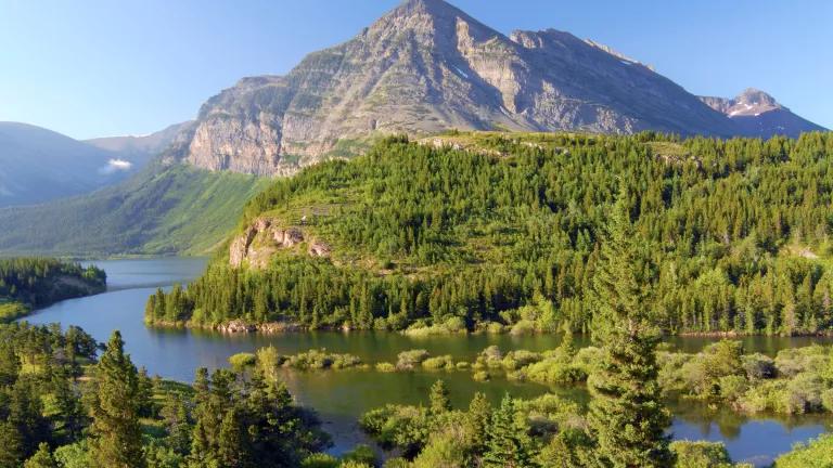
1. Glacier National Park, Montana
The alpine glaciers for which this park is named are rapidly retreating. They’re not only beautiful, but also responsible for the park’s unique habitats and features—especially its streams, which won’t flow year-round once the ice has melted for good. More than 70 species of mammals, 270 types of birds, and aquatic creatures like salmon will be affected.
Why it’s threatened: Heat-trapping pollution has caused global temperatures to rise, so glaciers are melting more in the summer and being replenished with less snow in the winter. More than 150 glaciers dotted this landscape in 1850, and most still existed by 1910 when the park was first opened to trainloads of curious travelers. A hundred years later, only 25 large glaciers remain; scientists predict that some of the largest ones will vanish by 2030 or earlier.
If you go: Take Amtrak’s Empire Builder line to Glacier National Park from Chicago or Seattle. Check out the Grinnell Glacier, Virginia Falls, and the park’s alpine lakes and meadows. All of these will likely change significantly in coming years.

2. Big Island, Hawaii
Hawaii has plenty of postcard-worthy views, from Punaluu’s volcanic black sand and sea turtles to Kona’s white sand and crystal-clear waters. Some are truly unique, too: Papakolea, on the southern edge of the Big Island, is one of just a few green-sand beaches in the entire world.
Why it’s threatened: Even though it’s halfway around the world, Hawaii (and the rest of the Pacific islands) will be hit disproportionately hard as glaciers in Greenland and Antarctica melt and cause ocean levels to rise worldwide. Coastal erosion in Hawaii is predicted to reach 20 feet in the next 35 years—meaning that some beaches will be completely swallowed by waves.
If you go: Getting to Papakolea Beach requires a winding but relatively flat 2.5-mile hike along the shore; when you reach the jaw-dropping green sand—colored by the volcanic mineral olivine—you’ll know the effort was worth it. The surf can be rough, and there aren’t any facilities, so take caution if you swim, and pack plenty of food and water.

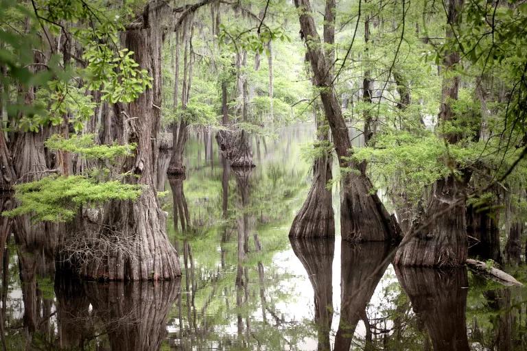
3. Everglades National Park, Florida
More than 1,700 keys, or shallow-water islands rising just a few feet above sea level, lie in Florida Bay. Many are mangrove-only outposts for fish and birds, but others are more substantial, with small, sandy beaches perfect for camping.
Why it’s threatened: The Everglades are perched on the edge of an ocean that is rising about five inches a century, according to 150 years of local data collection in south Florida. Although the entire Everglades area is threatened, the tiny Bay Keys are especially vulnerable. A popular campsite on Carl Ross Key has already been closed due to damage by recent hurricanes, and freshwater sources on other keys will likely soon be inundated with saltwater.
If you go: Little Rabbit Key is a 12-mile paddle from the mainland, and is one of four backcountry camping areas in Everglades Park. Bring your hammock and enjoy the crystal-clear waters that surround the island. The beach at Pavilion Key probably won’t exist in 30 years, so head there next.

4. Assateague Island National Seashore, Maryland and Virginia
People come for the wild horses (Assateague’s best-known feature), but stay for the 33 miles of undeveloped, natural beaches—a rare find so close to some of the country’s most densely populated areas.
Why it’s threatened: Erosion from increasingly intense storms combined with a three-foot sea-level rise by the end of the century will devastate the beaches of Assateague Island. Additionally, a 2012 NRDC report indicates that future summers on Assateague could get as unbearably hot as those currently in Key West. Sea-level increases could also displace freshwater sources, leaving animals (including the horses) without enough to drink.
If you go: Visit in July for the annual swimming of the ponies, and for ocean water warm enough to take a dip in. The area is part of the Atlantic flyway for migrating shorebirds, so early spring is the best time for birders.

5. Cape Cod, Massachusetts
The Cape is full of freshwater kettle ponds, formed in depressions left behind by retreating glaciers 15,000 years ago. For swimming, boating, and fishing, they’re a nice change from the sandy, salty ocean shorelines, and remarkably peaceful, too.
Why it’s threatened: Cape Cod’s coastal beaches have gotten most of the attention from scientists studying the effects of climate change, but its inland kettle ponds are also eroding as extreme weather events have increased. Steadily rising water temperatures are also depleting the ponds’ oxygen levels, creating dead zones where fish and wildlife cannot survive.
If you go: There are more than 365 ponds on the Cape. The most easily accessible kettle ponds—Round Pond and Snow Pond—are near the towns of Wellfleet and Truro. (Thoreau famously visited these during his time on the peninsula.)
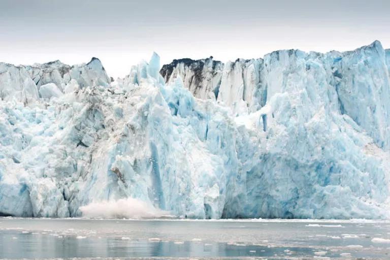
6. Columbia Glacier, Alaska
This huge glacier in south-central Alaska is iconic for its dramatic size, sculptural shapes, and color variation. It's also known for its link to climate change: It was featured in the 2012 documentary Chasing Ice.
Why it’s threatened: Warming temperatures have hit this glacier hard. The amount of ice that falls from it into Prince William Sound every year is more than five times the amount of freshwater used annually by the entire state of Alaska. First documented at 41 miles long in 1794, it will shrink to about 26 miles by 2020. It’s predicted to stop retreating at that point, but there’s little hope that it will recover.
If you go: You can get to the glacier by land, but kayaking in and experiencing it from the water will give you a more dramatic perspective. You’ll likely see giant pieces of ice calving from the main glacier as well as sea otters, whales, sea lions, and bald eagles.
7. Bayou Lafourche, Louisiana
A former outlet of the Mississippi River, this bayou is home to unique Cajun culture and abundant wildlife (everything from alligators to hawks). It also has just a few decades left before being swallowed by the Gulf of Mexico.
Why it’s threatened: All of Louisiana’s coastal bayous are being devoured by the rising sea, while the land around them is rapidly subsiding and eroding. (According to the National Oceanic and Atmospheric Administration, this region is experiencing some of the fastest sea-level rise in the world, with more than 16 square miles of land disappearing every year.) Many lowland areas of the Mississippi Delta have already been lost forever; mapmakers are struggling to keep up with the landscape’s dramatic changes.
If you go: Take in both the natural and human history of Louisiana’s coastal region by canoeing part (or all) of the Bayou Lafourche’s 65 miles. You’ll pass through small cities, rural towns, sugar plantations, and plenty of wildlife habitats. The Barataria-Terrebonne National Estuary Program hosts an annual 52-mile paddling trip, or you can head out on your own any time of the year.

8. Lake Mead, Nevada and Arizona
This human-created megalake was formed when the Colorado River was dammed by the Hoover Dam in the 1930s. It’s become a hugely popular lake for boating, hiking, swimming, and other recreation, with almost seven million visitors a year.
Why it’s threatened: Overuse of water from the Colorado River (for drinking, irrigation, mining, and manufacturing) and 15 years of lower-than-average rainfall have taken a heavy combined toll. Visible “bathtub rings” have formed as the water level has declined; in June 2015, Lake Mead reached its lowest level of all time. Projections for the next 30 to 50 years suggest the reservoirs of both Lake Mead and Lake Powell may empty entirely, depending on the severity of drought and future water restrictions.
If you go: Hike or cycle around the lake on the 34-mile River Loop Trail for a dramatic view of the disappearing body of water. Go November through March, when cooler temperatures prevail.
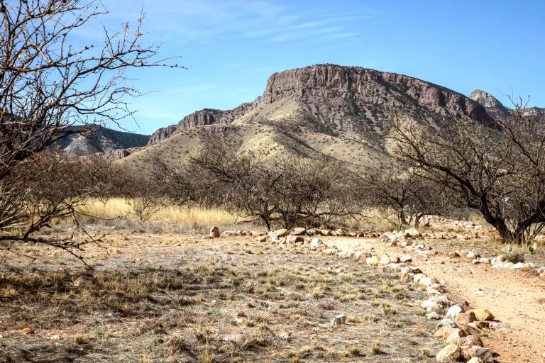
9. Sky Islands and the Madrean Archipelago, Arizona
More than 40 separate mountain ranges connect Mexico’s Sierra Madre to the Rocky Mountains in the U.S.; these ranges are known as sky islands because of the way they rise suddenly out of the surrounding desert lowlands. Steep elevation changes allow many different ecosystems and vegetation varieties to exist within just a few miles, making this one of the most biodiverse regions in the world.
Why it’s threatened: Rising temperatures caused by climate change will push these ecosystems higher and higher up the mountains, eliminating them one by one as the region warms.
If you go: On a 10-mile hike in the Pinaleño Mountains, the tallest of the Sky Islands, you can pass through seven different ecosystems and microclimates—from the floor of the Sonoran Desert, scattered with saguaro cacti and acacia bushes, up through grassland, chaparral, and woodlands. The mountain tops out at almost 11,000 feet, in a spruce-fir forest with quaking aspens and freshwater streams.
This NRDC.org story is available for online republication by news media outlets or nonprofits under these conditions: The writer(s) must be credited with a byline; you must note prominently that the story was originally published by NRDC.org and link to the original; the story cannot be edited (beyond simple things such as grammar); you can’t resell the story in any form or grant republishing rights to other outlets; you can’t republish our material wholesale or automatically—you need to select stories individually; you can’t republish the photos or graphics on our site without specific permission; you should drop us a note to let us know when you’ve used one of our stories.
Our Favorite National Parks
President Obama’s National Monument To-Dos Before He Leaves Office
The Endangered Species Act Under Attack