Life on the Mississippi, Now
We've spent billions of dollars on dikes, locks, and levees in a vain attempt to subdue what Mark Twain called "that lawless stream." Is it time to let the river have its way?

This story was originally published in June 2014 as the cover story of onEarth magazine's summer issue.
A bracing wind blew one final snowy vestige of winter into Hannibal, Missouri, last March, emptying the downtown streets on a Sunday afternoon. Six of us—two real estate agents, a furniture maker, two folk artists, and myself—took refuge inside Java Jive, which calls itself “the first coffee shop west of the Mississippi.” It was hard to dispute the claim: as the crow flies, the river passed just 700 feet away, across Main Street and beyond a tavern patio decked with metal furniture and an American flag.
Hannibal is where Mark Twain spent most of his boyhood dreaming of becoming a steamboat pilot. Half-artsy, half-tumbledown, it remains in the popular imagination the very embodiment of life on the Mississippi. Twain called it a “white town drowsing,” animated twice a day when a “cheap, gaudy packet” arrived from Keokuk, Iowa, or St. Louis. “Instantly a negro drayman, famous for his quick eye and prodigious voice, lifts up the cry, ‘S-t-e-a-m-boat a-comin’!’” he wrote in 1883. “The town drunkard stirs, the clerks wake up, a furious clatter of drays follows, every house and store pours out a human contribution, and all in a twinkling the dead town is alive and moving.” More than a century after Twain’s death, tourists still come to this city of 18,000 to visit his home and the river that inspired his books.
But looking out from Java Jive, I couldn’t see the river at all. Since 1993 it has been guarded by an earthen levee and a 12-foot concrete floodwall with gates that can be closed when the Mississippi overtops its banks. The levee kept downtown’s historic buildings dry during the Great Flood of ’93, which killed 50 people and caused $15 billion in property damage across nine midwestern states. But it didn’t protect Hannibal’s blue-collar bottomlands, where residents watched their modest homes fill with water, many beyond reclamation. Downtown might have suffered, too, if not for the failure of a levee across the river in Illinois, which inundated 45,000 acres and relieved some of the pressure on the Missouri side.

“It was really scary,” said Kristy Trevathan, one of the real estate agents at our table, who recounted the collective effort to shore up the floodwall with plywood and sandbags as the waters climbed ever higher. “That’s what builds community spirit—fighting the floodwater,” she said.
The 1993 deluge was called a 500-year flood, which means a disaster on that scale is predicted to occur only twice each millennium. The river exceeded flood stage for six months and crested at the highest level ever recorded at the Hannibal gauge. Then, in 2008, a 200-year flood sent residents sandbagging anew. Of Hannibal’s six highest crests, five have occurred since 1993, two of them last year alone. Punctuating these events have been droughts that hindered or threatened the barges that haul billions of dollars’ worth of grain, fertilizer, and petroleum products.
Scientists say flooding along the Mississippi is getting markedly worse, in large part because of how we’ve engineered the system and developed the river’s environs. Levees cut the river off from floodplains that, left undisturbed, would often extend for miles. Construction in those lowlands means we can no longer use them for natural flood control. Navigation structures like wing dikes—rock jetties that run perpendicular to the banks, constricting the channel—make floodwaters more turbulent, slowing their flow and raising them higher.
I guarantee you ... There will be a day. It’s going to come over our wall.
Compounding the problem is global climate change, which has been linked to some of the Midwest’s increasingly extreme weather, including the intense rainstorms that farmers here call “toad stranglers.” Researchers predict that heat waves, flooding, and drought will only grow more pronounced: a 2013 report commissioned by the Federal Emergency Management Agency (FEMA) projected that along the Mississippi, north of its juncture with the Ohio River in Cairo, Illinois, the amount of land inundated by 100-year floods will grow by anywhere from 30 percent to 60 percent by 2100. About 70 percent of that increase may be attributable to climate change.
Of course, these aren’t the Mississippi’s only woes. Fertilizer from farms, lawns, and golf courses flows down the river to create an oxygen-depleted dead zone in the Gulf of Mexico. Levees block sediment from replenishing the vanishing wetlands in the river’s delta. But in midwestern states like Missouri and Illinois, the number-one fear remains the constant and growing threat of flooding and drought.
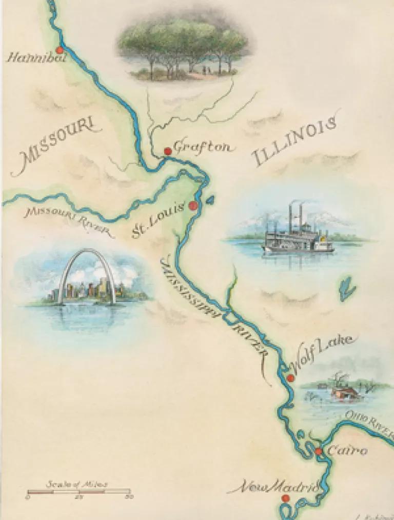
I was driving along a 300-mile stretch of the Mississippi between Hannibal and Cairo, two places that loom large in Twain’s writing, to talk with the people who cope regularly with the river’s rise and fall. In the author’s hometown, as everywhere, I found awe and resignation, wonder and fear—a sense that the natural order has become unhinged and uncertainty about how to react. “The Mississippi River: you love it, and it’s so calming in the morning when you see the sun rise over it,” said Trevathan. “But when it starts rising, there’s kind of an anxiousness.” The entire table nodded in commiseration. “I guarantee you,” said Mike Moore, the furniture maker. “There will be a day. It’s going to come over our wall.”
* * *
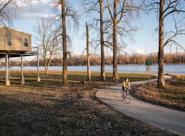
There’s no levee separating the Mississippi from Grafton, Illinois, 92 miles downstream from Hannibal—nothing but a bike trail, a marina, and a few homes elevated above harm’s way. Brewhouses and fish stands line Main Street, and the limestone bluffs offer a soaring view of where the Mississippi and Illinois converge. At the water’s edge I stood near a lighthouse built to symbolize the village’s recovery from the 1993 flood and watched a flock of pelicans huddle in the distance. A giant barge passed by, pushed upstream by a tugboat, the sound of its diesel engines the only thing disturbing the afternoon’s quiet.
How Grafton, population roughly 700, survived more than a century’s worth of aggressive levee-building policies is something of a mystery. State floodplain program manager Paul Osman has dug through files dating back to the 1920s without finding an explanation. According to Ed Amburg, a 79-year-old retired flour miller whose family has lived here since before the Civil War, there was never much of a demand. “We don’t want to go over a great big knob of dirt to get to the river,” he said. Regardless of the reason, the absence of a levee has turned Grafton into an experiment in how more natural river management might work.
Grafton markets itself as a weekend getaway, a place to sit on the deck of Aerie’s Winery, sip a glass of Confluence Conundrum, and contemplate the river’s roll. It wasn’t always like this. The riverbank used to be lined with fishing lodges, trailers, and Quonset huts, along with the wooden houses where old-timers lived. “They were good people: commercial fishermen, laborers, fish-market workers,” Amburg said. “Before everything got to where you had to have a big job to live, they survived very well.” Dealing with floods was second nature. “We even had one family that had a pig,” he said. “The high water come up, they’d put this pig on a raft. They’d tie him to the end of their house. Pig’s pretty smart. He’d stay on a raft too.”
Amburg and his wife, Bobbie, who is retired from Walmart, are among the few river dwellers who remain from that era. We sat on the ground floor of their house, Ed pouring me Milwaukee’s Best Lights through the late afternoon. (“You’re not drinking very fast,” he scolded me.) Next to us, their great-granddaughter studied her second-grade spelling words. The window offered a straight visual shot to the Mississippi, a view that never fails to stir the couple. “You sit in our yard and watch the boats that come and go, and it’s almost like you’re at a holiday site where they make pictures and you’ve got your own panorama,” said Bobbie. Every night before bed, she told me, her husband looks outside, sighs, and says, “Yep, it’s still there.”
The high water come up, they’d put this pig on a raft. They’d tie him to the end of their house. Pig’s pretty smart. He’d stay on a raft too.
The 1993 flood was not like the others. It plunged downtown Grafton under murky water that in some cases reached the rooflines. Houses collapsed and floated away. Displaced residents slept in tents, campers, and cars. “My city is gone,” then mayor Gerald “Windy” Nairn reportedly said as he laid his head on his desk and wept.
On the Amburgs’ bottom floor, the water came up to their noses, so they moved upstairs and lived there with jury-rigged electricity and no hot water. Ed took baths in the floodwater outside his house with a bar of Ivory soap, and navigated downtown’s streets in a boat. When the waters receded, he scraped away the mess with a wire brush. His lower-lying neighbors weren’t so fortunate: under federal policy, homes in a floodplain that suffer substantial damage must be moved, raised, or demolished. The policy, which applies to all houses no matter when they were built, predates the 1993 flood but was not widely enforced until then. According to Osman, enforcement still varies state by state.
Across the region, the 1993 disaster provoked a range of municipal responses. Some towns elevated their levees, hoping for better protection next time. The residents of Valmeyer, Illinois, 64 miles downriver, voted to rebuild their ruined village 400 feet up the bluff, this time as a modern suburb. In Grafton, Osman said, a “civil war” pitted those who wanted to repopulate the riverfront against those who wanted to clear it and use it instead for recreation and natural flood control.
The clearers won. FEMA paid for the voluntary buyout of 70 homes and 18 commercial buildings. Town officials steered new construction uphill. Entrepreneurs used the clean slate to open wineries, guesthouses, and a zipline. Now summer weekends bring traffic jams to Main Street. The current mayor, a soft-spoken retired school principal named Tom Thompson, wants to keep capitalizing on Grafton’s major asset, the open space along its unimpeded waterfront. He envisions an amphitheater, a covered bridge, and a bird-watching pavilion—low-impact structures designed to survive the flooding that Grafton still experiences. “We let the river come in,” he said. “And we let the river go out.”
Osman called this an environmentally—and, it turns out, economically—responsible approach to redevelopment. “Tom has really pushed the whole concept of living with the river,” he said. “With previous mayors, it was a battle. It was always fighting with the river. Tom has done a 180, and he’s embracing the river. And it’s really turned Grafton around.”
Thompson knows the job isn’t done. Many of the river dwellers have moved on, leaving Grafton with one-quarter fewer residents than it had before the flood. Weak home sales prompted the town in 2010 to offer free lots in an uphill subdivision; several remain unclaimed. With no grocery store anymore, buying food means driving 15 miles each way.
Ed Amburg gives credit to the entrepreneurs who helped jump-start the town after 1993. But he misses the time before tourists and wineries. “I knew everybody in Grafton. Wasn’t a soul I didn’t know,” he told me as the afternoon sun grew low. “Now I walk down Main Street and I’m lucky if I know anybody.”
* * *
The first 15 minutes of my drive south from Grafton were the most scenic. The Great River Road followed a narrow ribbon of land separating the Mississippi’s unleveed bank from the Illinois bluffs. The barges looked romantic; hardly a building came into sight; and it was easy to imagine the river as an unspoiled behemoth.
That illusion was short-lived. In Alton, the first city I came to, I watched from an 80-foot overlook as the Army Corps of Engineers hauled the front half of a liquid-cargo barge through the Melvin Price Locks and Dam. In operation since 1989, the twin locks move almost 70 million tons of cargo each year, half farm products and most of the rest chemicals, coal, and petroleum. The Mississippi is the main drag for the nation’s inland and intracoastal barge operators, who haul $73 billion worth of goods a year, one-sixth of all intercity freight by volume. Sixty percent of the grain grown for export in the United States reaches its international destinations by traveling downriver to the ports of New Orleans and South Louisiana.
The river looked less like the Amburgs’ “holiday site” and more like the spinal column of a vast industrial operation.
The Mississippi’s 29 lock-and-dam facilities, spread out along the 668 miles between Minneapolis and St. Louis, make navigation considerably more reliable. But they also create what the Washington University hydrologist and geochemist Robert Criss calls “a continuous stairway of flat-water lakes” rather than the “beautiful braided stream” and vibrant ecosystem that the Mississippi once was.
By the time I reached metropolitan St. Louis, 30 minutes later, the transformation was complete. The river looked less like the Amburgs’ “holiday site” and more like the spinal column of a vast industrial operation. Giant belt conveyers transferred fertilizer from barges to dome silos, where it awaited transportation to farms in the Midwest. Other conveyers carried corn, wheat, and soybeans to the barges that would haul them to the Gulf for export. Grain elevators, scrap-metal yards, floodwalls covered in cartoon graffiti, railcars filled with coils of steel—the river was gated off, no-nonsense, roaring with industry.
Still, industry remains at the river’s whim.
Early one morning I drove to St. Louis’s southernmost tip. Past a wheel-alignment shop and a gravestone vendor, past corner bars with identical Budweiser signs, I turned onto an industrial side street where truck trailers dotted the weedy lots. The road dead-ended at a chain-link fence, and eventually a security guard showed up to let me in. He directed me to walk down a metal staircase toward the river and across two gangplanks until I reached an old white casino boat with dark green trim. There, he said, I’d find a man named Goat.
James “Goat” Patterson owns Osage Marine, a business that assembles and breaks down “tows” of interconnected barges. It also transports barges between docks for loading and unloading. A northbound tow with 30 barges might hire Osage to split it into smaller segments that can fit through the locks north of St. Louis.
Patterson is a big man, with white hair and a ruddy face. His deep, precise voice conveyed a nostalgia for the days when smaller companies like his dominated the riverfront. “Everybody was honorable,” he said. “You didn’t have to have a contract. You would talk to somebody and say, ‘Hey, I need you to do this.’ They did it.” Now, with the industry’s consolidation, “you’ve got lawyers everywhere, and contracts. It’s just not as much fun.”
Since he started working in the industry in 1969, Patterson has seen another frustrating change: the river itself has become more capricious. When 2012 brought the worst drought in decades to the Midwest, barge operators were forced to lighten their loads to accommodate the shallower river. They carried fewer tons per barge, and fewer barges per tow, and raised prices so much that some customers switched to rail. The shipping channel grew so narrow in places that it could accommodate only one-way traffic. As the months dragged on, industry and political leaders predicted the river depth might fall below the nine feet needed for navigation, shutting down traffic between St. Louis and Cairo. They warned of “economic catastrophe in the heartland” and pleaded with the Army Corps of Engineers to release more water from Missouri River reservoirs into the Mississippi. That triggered an interregional conflict, as the Dakotas and other states said they needed the Missouri River water for drinking, irrigation, fish and wildlife, and recreation. The barge industry lost the battle—and was then dismayed to learn the corps had allowed an oil industry supply company, Select Energy Services, to withdraw “surplus” water from one of the reservoirs on the Missouri for hydraulic fracturing.
As it turns out, the Mississippi River closure never happened. But the drought’s impact still hurt Osage Marine. There were fewer barges to service, and low water meant less operating space near the riverbank. Patterson found himself running three boats instead of the usual seven, while also trying to keep his workers employed. “We’re a family-run company,” he said. “We kept everybody working some. Everybody’s got families and bills to pay. Unfortunately, they didn’t all earn what they’re used to earning, but everyone was getting something.”
A few months after the drought ended, the 2013 floods began, bringing Patterson a new set of challenges. It took longer to move barges in the strong current, driving up fuel costs. Driftwood barreling down the river tore up his vessels. “And it’s dangerous out there in high water,” he said. “It’s amazing how fast things happen.”
Until recently, scientists have had difficulty pinpointing the underlying cause of specific weather phenomena like the 2012 drought. That’s starting to change. A study by researchers at Oregon State University and the University of Oxford concluded that the drought likely resulted from random weather variation rather than climate change. But a Stanford University study, published simultaneously, said such summer heat waves are four times as likely to occur today as in the preindustrial era. Regardless of the reason for any particular event, researchers expect more wild oscillations as humans alter the climate. “We can’t tell you exactly what’s going to happen,” says retired brigadier general Gerald Galloway, a University of Maryland engineering professor and lead author of a study that President Clinton commissioned after the 1993 flood. “But it’s very clear, according to the best scientists in this country, that we’re going to have more intense rainfall events and [more] drought.” Both can increase flooding. “Intense drought over a long period of time can affect the stability of levees,” he says.
There’s an irony in the barge industry’s woes. The very infrastructure that is designed to make navigation easier may also be worsening the Mississippi’s floods. Nicholas Pinter, a geologist at Southern Illinois University, has compiled a database of more than eight million hydrological measurements and used it to examine various explanations for the growing intensity of floods. While climate change played a statistically significant role, he wrote in a 2008 study, “the largest and most pervasive contributors to increased flooding on the Mississippi River system were wing dikes and related navigational structures, followed by progressive levee construction.” On the upper river, those two factors added more than six feet to 2008’s levee-smashing crests.
Structures like wing dikes are designed to help barges by concentrating the river’s flow in the navigational channel. “They do that effectively,” said Pinter. “But they [also] act as impediments to the conveyance of floodwaters when a flood does occur.” This puts him and other scientists at odds with the Army Corps of Engineers, which interprets historical data differently and insists the structures have no such impact. It continues to build dikes and other related hardware south of St. Louis.
About 100 miles downriver, I met some of the young people who will inherit the impacts of the corps’ decisions. Wolf Lake, Illinois, is an unincorporated soybean- and corn-growing community with a palpable sense of generational continuity. “I’m going to the school my dad went to,” said Justin Goodman, a loose-limbed 18-year-old baseball player. “And I would like for one day my kids, my grandkids, to go to the same school I went to.” But Goodman, who studied river structures in his social studies class at Shawnee High, worries that his family and neighbors might be in peril: not only is that stretch of the Mississippi thick with wing dikes, but the corps has proposed installing even more hardware there, including experimental structures called S-dikes.
The corps says the dikes would improve navigation and reduce the need for dredging. Pinter, the geologist, calls the plan “particularly ill chosen,” noting that S-dikes are “untested inventions.” Adding stress to a substandard levee like Wolf Lake’s during high water, he says, could potentially trigger a breach. That, in turn, would destroy Goodman’s home and many others. “Wolf Lake wouldn’t exist where it is anymore,” the student told me. “It would be gone.”
* * *
If there was one part of my trip that showed the consequences of the present ways of dealing with the vagaries of the river, it was the final leg before the Mississippi’s confluence with the Ohio. Here, in 2011, flooding hit hard, threatening to drown Cairo, a once-prosperous river town built on a peninsula where the rivers meet. To save lives and property, the corps prepared to do something it had done only once, in 1937: intentionally blast open a downstream levee on the Missouri side, flooding about 133,000 acres of farmland where fewer people lived.
The Birds Point–New Madrid Floodway was created under the Flood Control Act of 1928, and the government paid the Missouri farmers compensation in advance for the occasional flooding they might endure. Scientists and government leaders consider the floodway essential to public safety. One Illinois environmental official compared Missouri’s levee to the kink in a hose. “Open it up as God intended and the water will go straight downstream rather than backing up and causing increased flooding upstream,” he said in an e-mail.

Even though the other side of the Birds Point Levee was designated for flood control, some Missourians built homes there and depend on its rich soil for their livelihoods. The plan to open the levee angered them. “When I built this house, I knew there was a risk,” said Larry Allred, a soybean and wheat farmer. “But I didn’t know somebody was going to start playing with dynamite.” In late April 2011, with the waters rising, Missouri’s attorney general sued to halt the deliberate flooding, and lost. Because of the litigation and the corps’ own hesitation, it wasn’t until the water was lapping at Cairo that the Missouri levee was dynamited. The river level plunged and Cairo survived.
But the delay caused suffering elsewhere. Twenty-eight miles upstream from Cairo, a local levee failed just hours before the Missouri blast, filling rural Olive Branch, Illinois, like a bathtub. Sidney Miller, a corrections officer who ran a farm supply store at the time, fled by boat in the pouring rain at 1:30 a.m.—he was bitten by a snake during the evacuation—and later discovered that his house and business were too damaged to repair. “I lost my life,” he said as we sat in his late parents’ home, which he bought after the flood. Sometimes, Miller visits the wreckage of the blue house he owned for 30 years just off the two-lane highway through town. “I open the door,” he said, “and just kinda cry.”
After the waters receded, Miller headed up a community effort to explore moving Olive Branch out of the floodplain. Neighbors visited other disaster-plagued communities, including Valmeyer, 115 miles upstream, which was relocated to the top of a bluff, placing it entirely out of harm’s way. But FEMA buyout funds were slow to arrive, and by the time they did, the momentum had dissipated. “There was an open window of opportunity when feet and belongings were wet,” said Pinter, who worked with the residents. “The fact that it took two years, even though that’s faster than anyplace else, it’s still too long.”
Miller remembered how, immediately after the corps opened the Missouri levee, the water in Olive Branch fell quickly—as if someone had unplugged a bathtub drain. He still thinks that action taken a few hours sooner might have saved his community from destruction, and gets angry at politicians for contributing to the delay. “They fought it with their money and their lawyers,” he said, “and it took one day too long for us. One day. One day.”
* * *
By the time I reached Cairo, the weather had warmed up considerably since that snowy afternoon in Hannibal five days earlier. From a literary perspective, it made for a fitting bookend to my trip. In Mark Twain’s Adventures of Huckleberry Finn, Huck and the runaway slave Jim traveled down the Mississippi on a log raft, heading for Cairo, where Jim hoped to catch a northbound Ohio River steamboat and secure his freedom. (It didn’t work out that way.) Of the real place, Twain wrote, “Cairo is a brisk town now; and is substantially built, and has a city look about it.... Her situation at the junction of the two great rivers is so advantageous that she cannot well help prospering.”
When Twain wrote those words, Cairo had more than 9,000 residents and was heading toward a peak of about 15,000. The post–Civil War years had brought a “booming riverboat trade,” a local newspaper noted in 1909, transforming the town into “a curious mixture of violence and gentility”—saloons and casinos just “a discreet carriage ride away” from the palatial mansions along ‘Millionaire’s Row.’
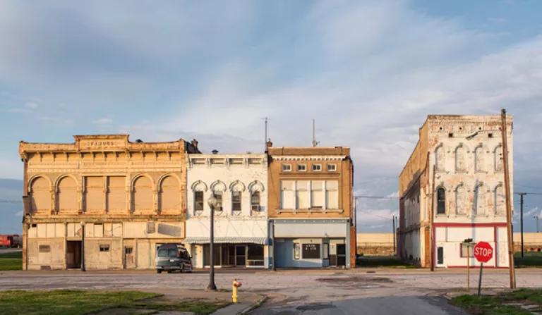
Today fewer than 2,700 people live in Cairo. A few mansions remain. But some of the street signs are rusted and illegible, and stop signs have bleached out. Whole blocks have disappeared, leaving nothing but rubble. The decline of the river trade, followed by some of the nation’s ugliest conflicts during the civil rights era, fostered a long and seemingly irreversible decline. Local officials have grown so fatigued by unflattering news coverage that city treasurer Preston Ewing Jr. asked me to stay away. He told me his city has not been deluged since the mid-1800s, making it irrelevant to my story. “Every spring there’s a flood threat. That’s a part of life,” he said. “But Cairo has been blessed.”
In 2011, however, no one knew if that blessing would hold. Jeff Denny, the county engineer, recalled the immense sand boil that erupted on the north side of town, spouting river water and sand, geyser-like, “like nothing anyone had ever seen.” The boil was stealing sand from the levee, threatening its structural integrity. To equalize the water pressure and halt the damage, Denny and others built a cinder-block ring around the boil, 80 feet in diameter and 12 feet tall. They started at sunset. “At three in the morning, we didn’t know if we were going to be able to slow it down,” he said. Only at dawn did they get the boil under control.
“The Cairo levee was teetering on the edge of failure,” Pinter said. “And only by heroic efforts and luck, and last-minute action by the Corps of Engineers”—in opening the Missouri floodway—“did it not fail.” With disaster potentially imminent, the mayor ordered an evacuation.
Before leaving town I visited a senior citizen residence where two cousins, Mary and Tina Meeks, live in balcony apartments overlooking Cairo’s floodwall. Mary, 69, who has worked as a teacher’s assistant, a farmworker, a janitor, and a home-health aide, recalled evacuating to a nearby college in 2011, where she spent two weeks sleeping in a gymnasium with some “unsanitary” characters who drank, cussed, and wet their cots. She doesn’t expect to see another crisis of that magnitude in her lifetime, and sees no reason to move. “I’m too old to go to the city to live,” she said. “I can’t be running and dodging bullets. So I might as well stay here.”
But Tina, who is 74 and used to work at a preschool, said she’s dodged enough bullets. “I’ve got my bag packed, all my emergency papers,” she said. Next time it floods, “I’m gone. And I am not coming back.”
* * *
More than 130 years ago, Mark Twain foretold our folly in thinking we could wrangle the Mississippi River to meet our own needs. “Ten thousand River Commissions, with the mines of the world at their back, cannot tame that lawless stream,” he wrote, “cannot curb it or confine it, cannot say to it, Go here, or Go there, and make it obey; cannot save a shore which it has sentenced; cannot bar its path with an obstruction which it will not tear down, dance over, and laugh at.”
Everything we’ve done to subdue the river has triggered a backlash, and the cumulative damage promises to come into starker relief as the climate changes. The solution doesn’t lie in a hydrological arms race. It lies instead in what Pinter calls “facing up to this problem, taking a gentle step or two back, and allowing more room for the river.” This means admitting that a 500-year and a 200-year flood do not randomly occur 15 years apart, and developing policies based on more realistic assessments. And not building subdivisions and industrial parks behind ever-higher levees. And making better use of floodplains—lowering or removing some levees and installing gates in others that can be opened to flood land in a controlled manner. And setting limits on barge traffic based on the river’s capacity rather than continuing to build endless dikes. And making it easier to relocate homes and businesses, using federal funds, before the next flood.
Engineering won’t solve the problems that engineering caused. “The river has a job to do: to move water and mud to the Gulf of Mexico,” says Robert Criss, the hydrologist and geochemist. “The river is doing that job, in the natural state, in the most efficient way possible. Then we come along and think we can do better. And it’s a fool’s game.”
This article was originally published on onEarth, which is no longer in publication. onEarth was founded in 1979 as the Amicus Journal, an independent magazine of thought and opinion on the environment. All opinions expressed are those of the authors and do not necessarily reflect the policies or positions of NRDC. This article is available for online republication by news media outlets or nonprofits under these conditions: The writer(s) must be credited with a byline; you must note prominently that the article was originally published by NRDC.org and link to the original; the article cannot be edited (beyond simple things such grammar); you can’t resell the article in any form or grant republishing rights to other outlets; you can’t republish our material wholesale or automatically—you need to select articles individually; you can’t republish the photos or graphics on our site without specific permission; you should drop us a note to let us know when you’ve used one of our articles.
Great Lakes Levels Are Rising—a Sign of Things to Come?
Can We Save the Midwest’s Only Rattlesnake?
Can the Great Lakes Become Fishable, Drinkable, and Swimmable Again?