Great Lakes Levels Are Rising—a Sign of Things to Come?
Stronger storms and harsher cold snaps could mean more dramatic ups and downs for lake levels in the future.
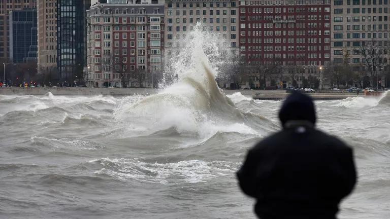
Storm waves crashing along the shore of Lake Michigan in Chicago
Scott Olson/Getty Images
Those of us living along the shorelines of the Great Lakes are in for a ride. Water levels in Lakes Superior, Erie, and Ontario hit historic highs this past summer, and Lakes Michigan and Huron came within one inch of their highest levels recorded since 1986. Waves lapped over bike paths and splashed onto roadways. Sand and land washed away. Altogether, lakefront conditions were, and still are, wet and wild.
“We’re seeing significant waves and extreme erosion along the lakeshore,” says Keith Kompoltowicz, chief of watershed hydrology for the U.S. Army Corps of Engineers’ Detroit District. The lakes swallowed beaches in Chicago and Michigan while erosion threatened homes, buildings, and other infrastructure.
Why are these waters so high? For starters, the past five years have been the wettest ever recorded in the region. In the past 60 months, 27 more inches of rain than average fell in the Great Lakes Basin. As a result, Lake Superior is 15 inches higher. Lake Ontario? Twenty inches higher. Lake Erie is 29 inches higher, and Lakes Michigan and Huron, which connect through the Straits of Mackinac, are together a whopping 35 inches higher.
We could see even more dramatic swings in water levels thanks to climate change. More than a century of hydraulic and hydrological data on the Great Lakes, collected by the National Oceanic and Atmospheric Administration, shows us that evaporation and precipitation (snow, rain, hail, and those lovely wintry mixes) dictate how high or low the lakes get, and we’re now seeing more extreme weather events that influence both of those processes.
Typically, water levels begin to rise in the spring when rain falls on the lakes or trickles in from the land and when snowmelt floods the tributaries that empty into the lakes. Over the summer, those levels peak. Come autumn, the weather is typically cool and dry, and lake water evaporates. By winter the lakes have reached their lowest points.
Floodwater covering much of Montrose Beach in Chicago after high lake levels inundated the area in June 2019
Scott Olson/Getty Images
But this year, after years of wetter-than-normal conditions, six rainfall events in May sent lake levels surging across the Great Lakes Basin. That pattern is consistent with climate change models that predict midwestern rainstorms dropping more water over shorter time frames than in the past. Warmer temperatures allow the atmosphere to hold more moisture, which can lead to more severe storms, and such events continued to drench the region throughout this past summer and fall.
Rising lake levels are just part of the story, though. A warming climate can also lead to sudden dips in water levels. In 2013, Lakes Michigan and Huron hit record lows, and the others were well below average due to lower-than-normal rainfall and higher air temperatures that lead to more evaporation, two more consequences of climate change.
The Great Lakes themselves are, on average, at least 1.5 degrees Fahrenheit warmer than they were in 1995. Lake Ontario is a full 2.2 degrees warmer. This is happening worldwide. On average, the world’s lakes are warming by 0.61 ℉ per decade. But of 235 lakes studied across six continents, the authors of a 2015 paper found that Lake Superior was warming the fastest, its temperature rising at three times the global rate, thanks to climate change. And warmer water can mean more evaporation.

Lake Superior’s shoreline before and after a heavy rainfall in 2018. The red and orange areas along the shore are sediment from the rivers that carried muddy floodwater into the lake.
NASA
Low temperatures can have consequences, too. The polar vortex events that have gripped the Midwest in recent years supercool the lakes. Caused by a wobbling stream of Arctic air that dips to lower latitudes as the pole warms and ice melts (again, thanks to climate change), these frigid weather patterns reduce evaporation, effectively freezing lake levels for the season.
For the Great Lakes’ coastal ecosystems, the effect of more pronounced fluctuations in water levels is a mixed bag: Some animals, like muskrats and spawning fish such as pike, thrive when waters are high but may suffer when levels drop. As lakes rise and fall more severely, experts say more consideration needs to be given to those creatures living along their shores.
Since 2010, local and federal governments have spent $2.5 billion, through the Great Lakes Restoration Initiative, on freshwater infrastructure such as improved drainage systems and green spaces to replace impervious concrete. They’ll have to go even further to protect buildings and shorelines by anticipating local climate impacts. This will be a challenging undertaking for city planners. Though prediction methods over the longer term have improved, scientists still can’t say for sure what will happen 5, 10, or more years out.
Dedicating more resources to regional climate change models would help, says Drew Gronewold, an associate professor of environment, sustainability, and civil and environmental engineering at the University of Michigan, Ann Arbor. The Great Lakes are a complicated hydrological system: “They freeze, produce lake-effect snow, and change how cloud and weather patterns form,” he says. And compared with other regions like the arid Southwest or damp Pacific Northwest, relatively little research is focused on the lakes. Having a better idea of what may happen to one of the largest freshwater systems on the planet could help elected officials prepare for the future and protect the 30 million people who live in the Great Lakes Basin.
In the coming months, we’ll likely continue to see high lake levels. This autumn’s weather wasn’t as cool and dry as normal, so the proverbial faucets didn’t turn off, says Kompoltowicz. The Army Corps of Engineers forecasts lake levels six months out; as of now, it looks like the lakes could kick off 2020 even higher and reach new record levels by winter’s end.
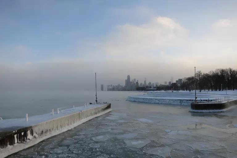
Lake Michigan froze during the polar vortex that overwhelmed Chicago in 2014
Edward Stojakovic via Flickr
But at some point, Kompoltowicz says, “the conditions are going to push the level down again.” That leaves lakeshore communities scrambling for funds to restore shorelines torn apart and washed away by swelling and retreating waters. In Chicago, officials say the city needs $500 million in federal funds to put up barriers along eight miles of shore. The state government has committed to another $45 million to repair damages. In the meantime, residents of buildings along the lakes are fearful of storms that could force them to evacuate.
Photographs from drones flown over the lakeshore this past summer are helping city officials determine how, exactly, the shifting shoreline has changed. Those massive fluctuations are only making people feel uncomfortable right now, says Gronewold, but “if it gets really bad, they damage property and they take human lives.”
This NRDC.org story is available for online republication by news media outlets or nonprofits under these conditions: The writer(s) must be credited with a byline; you must note prominently that the story was originally published by NRDC.org and link to the original; the story cannot be edited (beyond simple things such as grammar); you can’t resell the story in any form or grant republishing rights to other outlets; you can’t republish our material wholesale or automatically—you need to select stories individually; you can’t republish the photos or graphics on our site without specific permission; you should drop us a note to let us know when you’ve used one of our stories.
Life on the Mississippi, Now
How Melting Ice Affects People and the Planet
What Will It Take to Tackle Water Scarcity on the Navajo Nation?