These Photographs Show How the Rising Sea Connects Us All
In images both beautiful and disturbing, photographer Kadir van Lohuizen documents how sea level rise is altering coastlines—and lives—around the world.
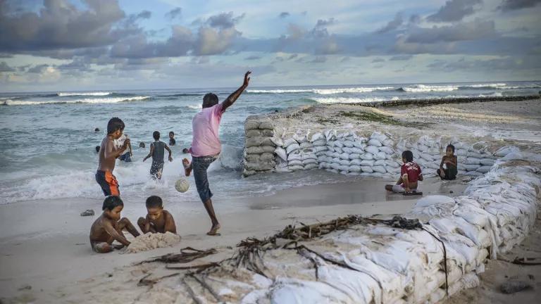
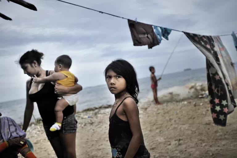
Children play on a fortified beach in Temwaiku, a village on the Tarawa atoll, the capital of the Pacific island nation of Kiribati.
All photos by Kadir van Lohuizen / NOOR
Long before he began documenting the impact of rising sea levels around the world, Dutch photojournalist Kadir van Lohuizen was well aware of water’s capacity to destroy—and of people’s capacity to adapt. In 1953, a decade before he was born, massive flooding in his native country killed more than 1,800 people and displaced 70,000 more. During a two-day storm surge that also destroyed 10,000 buildings, nearly a tenth of all Dutch farmland disappeared beneath the water.
With almost a third of the Netherlands resting below sea level, the Dutch, Van Lohuizen says, have always been “aware of how vulnerable their country can be.” So important is flood management to Dutch society that schoolchildren are required to draw pictures proving their basic knowledge of dyke engineering.
Today, nearly 70 years after that destructive Dutch flood, rising waters from the North Sea to the Bay of Bengal to the Pacific Rim to the Atlantic coasts of the Americas are threatening the lives and homes of billions of people. And waters aren’t just rising higher: They’re rising higher faster. According to the United Nations’ Intergovernmental Panel on Climate Change, global mean sea level rose by about 0.06 inch annually over the first 90 years of the 20th century. But in the single decade between 2005 and 2015, that rate accelerated to 0.14 inch per year. If global greenhouse emissions aren’t curbed, IPCC experts warn, sea level is likely to rise between 2 to 3.6 feet by the end of this century—and a rise as high as 6.5 feet “cannot be ruled out.” In almost every scenario, the authors note, “extreme sea level events that were rare over the last century will become common before 2100, and even by 2050 in many locations.”
Ten years ago, Van Lohuizen began photographing the impacts of these extreme events around the world. His photos—taken over the course of several years in Greenland, the Netherlands, the United States, Panama, Indonesia, Bangladesh, and several Pacific island nations—tell stories of devastation, but also of human beings’ extraordinary gifts for creativity and adaptation.
Now they can be experienced in a volume that combines these many different stories into a single, powerful account. In its 286 pages, After Us the Deluge: The Human Consequences of Rising Sea Levels from Lannoo Publishers shows us, in stark and vivid detail, what climate change’s human toll actually looks like. (The book has been published in conjunction with an exhibit, Rising Tide: Visualizing the Human Costs of the Climate Crisis, on display at the Museum of the City of New York through the end of the year.)
The world can’t afford to ignore these images. Many of his subjects, Van Lohuizen says, “feel like they aren't being heard, like they aren’t being listened to. Especially in places like Bangladesh or the Pacific states, these people feel like they are having to pay the highest price for a problem that they didn’t play any part in creating.”
Greenland
The rapid melting of Greenland’s ice sheet, the second-largest body of ice on earth after Antarctica, is the main driver of sea level rise around the globe. The melting season in Greenland’s north now lasts 70 percent longer than it did just 50 years ago. And in 2012, surface melt, which normally affects only portions of the ice sheet during the summer, occurred across nearly the whole ice sheet for the first time in recorded history. Were the ice sheet to melt entirely, the earth’s oceans would rise on average by nearly 23 feet, leading to worldwide catastrophe. Van Lohuizen’s images of retreating glaciers are as beautiful as they are disturbing; other photos depict Greenland’s relatively few inhabitants learning to adapt to their abruptly altered landscape and warming climate.
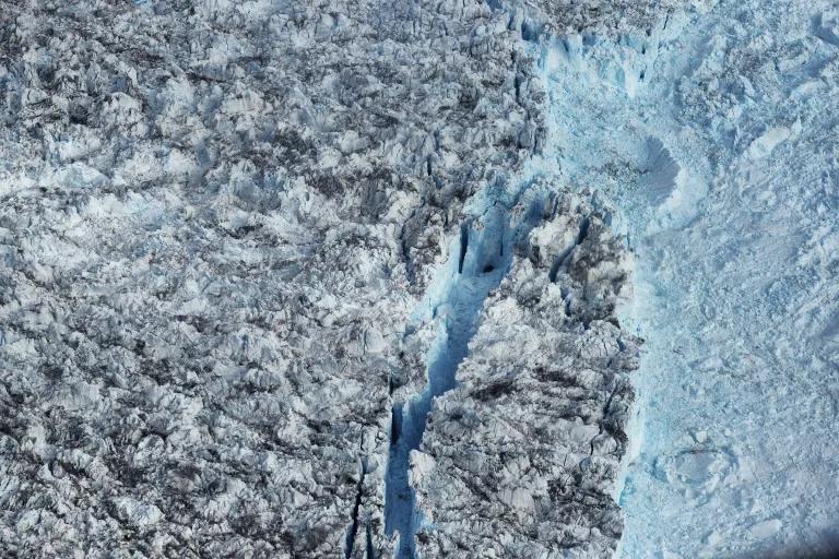
Near the town of Ilulissat, Greenland, a massive piece of ice cleaves off Sermeq Kujalleq, one the world’s fastest retreating glaciers.
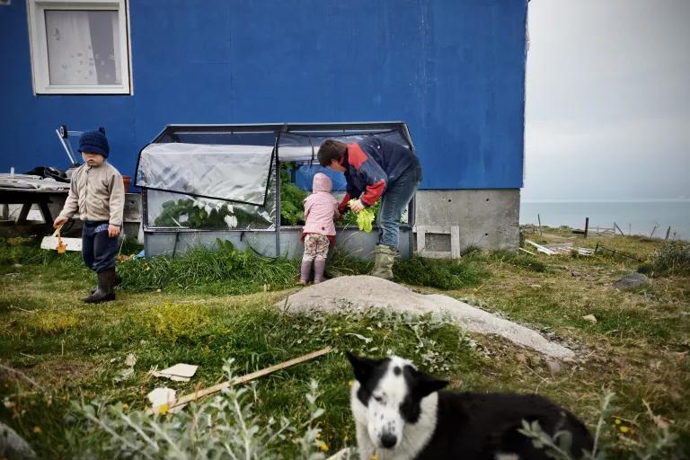
Higher temperatures in southern Greenland mean that families like this one can now grow crops—such as lettuce and strawberries—that previously wouldn’t have survived here. Meanwhile, in Greenland’s north, Indigenous hunters are having more difficulty finding food as wildlife struggle to adapt to their new ice-free habitat.
The United States
Although rising sea levels threaten communities all along the U.S. coast, Van Lohuizen focused his camera on two major cities thought to be at special risk: New York City and Miami Beach. New York received a taste of what the future could hold during Superstorm Sandy, a 900-mile-wide storm that battered the metropolitan area in 2012, killing dozens, destroying thousands of homes and businesses, and forcing the closure of the subway system and tunnels leading into and out of Manhattan. In Miami Beach, seasonal tidal surges frequently reverse the flow of the city’s drainage system, pushing sewage-tainted seawater up through street-level storm drains. In his photographs of both cities, Van Lohuizen seems especially interested in the disconnect between the reality of sea level rise and the prospect of continued development—especially the luxury buildings in some of Miami Beach’s wealthiest communities, which also happen to be the ones most at risk of destruction.
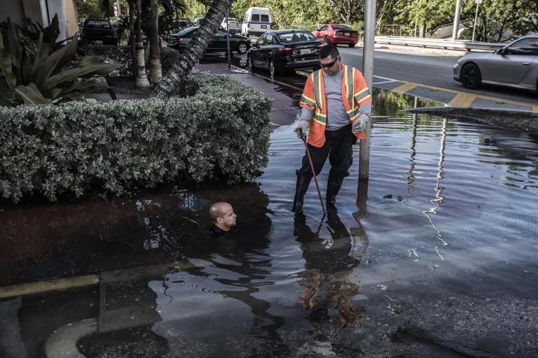
During king tide in Miami Beach, a worker checks on the status of a storm drain while almost completely submerged in seawater.
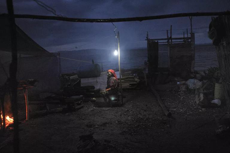
Panama
In 2011, Van Lohuizen went to northern Panama as part of a project on mass migration. While staying with the Indigenous peoples of the San Blas archipelago, he learned just how significant a factor sea level rise was in their displacement—and his next project was born. "I was still a bit naive,” Van Lohuizen recalls. “I asked them why they were being evacuated, and they said, ‘The sea is rising, there are more frequent storms, and we can't grow our crops anymore.’ That was the wake-up call for me. I knew that if it was happening there, it was happening elsewhere. That's when I started researching, looking for regions in the world where there was this same sense of urgency." Back then, he says, the members of these communities “didn't want to leave the land of their forefathers. But when I went back in 2015, they were desperate to leave because it had become so dangerous."
Rising waters forced this Indigenous Guna Yala family to relocate to Sucunguadup, part of the San Blas archipelago, where they bolstered the island with coral—an ill-advised strategy that can put them more at risk from encroachment of the sea.
A 2007 storm washed away part of Venilda Arcia’s home on Cartí Sugtupu, another island within the San Blas archipelago, where she lived with her daughter and son-in-law. During the rebuilding, which took many years, they moved in with 15 other family members.
Indonesia
Despite the fact that the northern stretches of the Indonesian capital of Jakarta have been sinking nearly 10 inches each year, Van Lohuizen was initially hesitant to include the city in this project. “One of the big reasons it’s sinking is because of groundwater overextraction,” he says. “I was nervous about climate skeptics saying that sea level rise wasn’t in fact to blame” for its designation as the fastest-sinking city in the world. Then he realized that “it’s precisely this combination—a sinking city, plus a rising sea level—that makes it so vulnerable.” The greater Jakarta metropolitan area is home to more than 30 million people; if subsidence and sea level rise continue at their current rates, experts say, much of this area will be underwater within two decades.
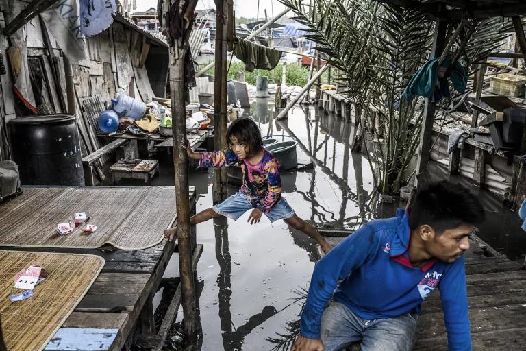
A young girl straddles the gap between footholds in her flooded community in the north of Jakarta.
Pacific Nations
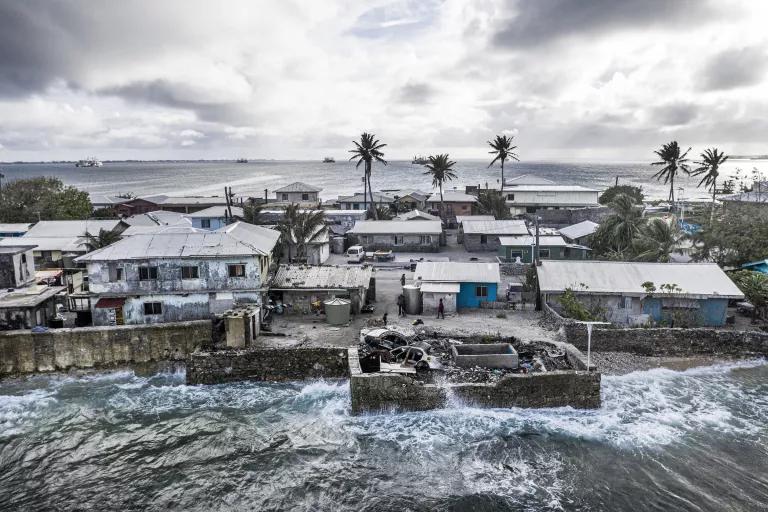
For many Pacific nations, rising sea levels quite literally pose an existential threat: Atoll islands such as Kiribati, the Marshall Islands, Tuvalu, and the Maldives, to name just a few, are in danger of disappearing over the coming decades. In the meantime, more frequent and more intense floods are destroying crops, homes, and the aquifers that residents require for drinking water, forcing many people into migration. Van Lohuizen believes that intergovernmental organizations such as the United Nations aren’t adequately preparing for the likelihood that entire land masses will simply vanish. “What do you do with people who have lost their country?” he asks. “What happens to their language? What happens to their culture?"

A lone arboreal survivor of coastal erosion in Vunidogoloa, a village on Fiji’s second-largest island of Vanua Levu. In 2014, all 153 villagers needed to relocate several miles inland.
In Majuro, capital of the Marshall Islands, residents have had to build homemade seawalls to protect their homes and communities.
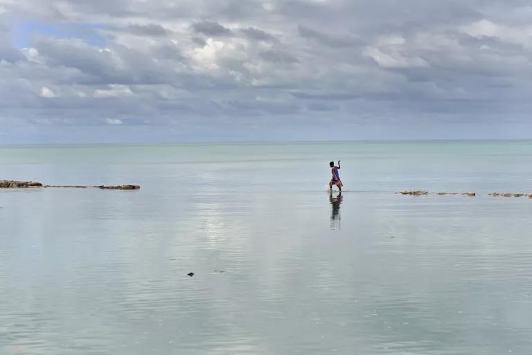
A woman navigates across a failed attempt to reclaim land in the lagoon of Tarawa, on the Pacific island nation of Kiribati.
Bangladesh
Climate change has displaced, and continues to displace, tens of millions of people worldwide—but no country has experienced this phenomenon as acutely as Bangladesh. Cyclones, storm surges, and other extreme weather events have caused large swaths of the country’s rural population to flee ruined farmland and move to already overcrowded urban areas, many of which are highly vulnerable to sea level rise and the flooding it brings. Natural disasters forced nearly 5 million Bangladeshis to relocate between 2008 and 2014, and a rise in sea levels of three feet could force an estimated 30 million more into migration. But in addition to relocating, Bangladeshis are also trying to adapt to their changing landscape. On one island in the Bay of Bengal, Van Lohuizen recalls, rice farming had been the main economic activity. “But flooding destroyed rice production. And then someone came up with the very good idea that they could mine sea salt from the flooded land, and so the rice paddies became salt paddies.”
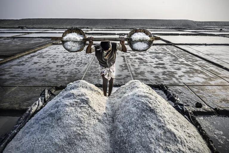
Rice farms once flourished on the Bangladeshi island of Kutubdia, in the Bay of Bengal. Now the local rice farmers mine sea salt from the flooded paddies.

A busload of climate refugees on their way to protest the proposed demolition of their neighborhood in Chittagong, on Bangladesh’s southeastern coast.
The Netherlands
With a history of flooding that reaches back centuries, Van Lohuizen’s home country has developed effective flood management tools over time. Despite this, Dutch experts say that no amount of preparedness is a match for the damage that a worst-case climate scenario would cause. “In the Netherlands, one meter of sea level rise could be handled,” Van Lohuizen says. “Two would be difficult. But three would be catastrophic. And at the current rate, we could face three meters by the end of the century. It’s hard for many people to imagine that these historic cities like Rotterdam and Amsterdam could simply disappear. But it’s not inconceivable.”
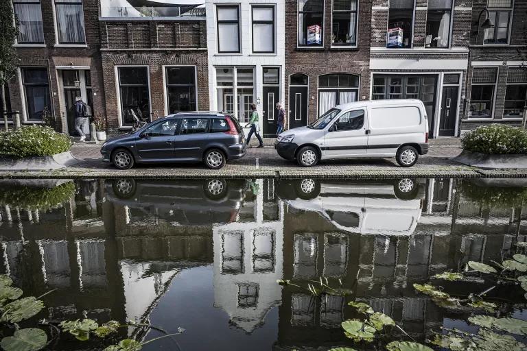
The Dutch city of Gouda has one of the Netherlands’ highest sinking rates. A solution would be to pump out the water but doing so would expose the stilts holding up its houses to oxygen, which would cause the buildings to collapse. With the additional stress of rising sea levels, the prognosis for Gouda’s future is grim.
Rising Tide: Visualizing the Human Costs of the Climate Crisis is on display at the Museum of the City of New York through January 2, 2022.
This NRDC.org story is available for online republication by news media outlets or nonprofits under these conditions: The writer(s) must be credited with a byline; you must note prominently that the story was originally published by NRDC.org and link to the original; the story cannot be edited (beyond simple things such as grammar); you can’t resell the story in any form or grant republishing rights to other outlets; you can’t republish our material wholesale or automatically—you need to select stories individually; you can’t republish the photos or graphics on our site without specific permission; you should drop us a note to let us know when you’ve used one of our stories.
A Race to Track the Southern Seas
Climate Tipping Points Are Closer Than Once Thought
What Are the Effects of Climate Change?