U.S. Wetlands and Streams Are Already Losing Protections—Why Make It Worse?
NRDC’s GIS analysis shows that the EPA’s proposed implementation of Sackett v. EPA would weaken Clean Water Act protections for wetlands and streams more than is required.


In November 2025, the U.S. Environmental Protection Agency (EPA) and the U.S. Army Corps of Engineers published a proposed rule that would roll back existing regulations that specify what waterbodies the Clean Water Act protects from pollution and destruction. The EPA and the Corps claimed to be implementing a U.S. Supreme Court decision called Sackett v. EPA, but the proposed rule would weaken the Clean Water Act significantly more than the Court’s opinion required.
Sackett itself already greatly restricted the scope of the Clean Water Act. It declared that streams had to be “relatively permanent” to be protected, which undermined the law for rain-dependent streams. It also declared that wetlands could only be protected if they have a “continuous surface connection” to relatively permanent waters, which means geographically “isolated” wetlands, no matter how important they are for the health of other waters, could not be protected.
The proposed rule goes much further than even Sackett. It would only protect streams that have continuously flowing water throughout the “wet season,” a concept that the agencies don’t define and that will be difficult to identify. Also, waterbodies upstream of tributaries that don’t meet this “wet season” requirement would lose protection. Finally, and incredibly, the proposal would prohibit protecting any wetland unless it has aboveground water throughout the “wet season.” Nationwide, at least 86 percent of freshwater wetlands would lack protection under the EPA’s proposal.
Because the EPA and the Corps refused to undertake any meaningful analysis of how their proposal would affect waterbodies nationwide, NRDC used GIS tools and national datasets to estimate the impacts that the proposed rule would have. NRDC recently submitted our results to the EPA and the Corps as an official public comment on the proposed rule.
Learn More

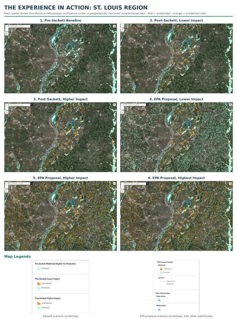
Building off NRDC’s March 2025 Mapping Destruction analysis, this map shows five different implementation scenarios, with protected waters marked in teal and unprotected waters in orange:
- Pre-Sackett Wetlands Eligible for Protection: All tributary streams are protected; all wetlands meeting regulatory criteria are protected.
- Post-Sackett, Lower Impact: Both perennial and seasonal streams are protected; wetlands intersecting other protected waters are protected.
- Post-Sackett, Higher Impact: Only perennial streams are protected; wetlands intersecting other protected waters are protected.
- EPA Proposal, Lower Impact: Both perennial and seasonal streams are protected; waters upstream of rain-dependent streams are excluded; only wetlands that both intersect other protected waters and semipermanently flooded or wetter areas are protected; human-created or -altered waters (like ditches and canals) are excluded; lakes and ponds less than five acres in area are excluded.
- EPA Proposal, Higher Impact: Only perennial streams are protected; waters upstream of rain-dependent or seasonal streams are excluded; only wetlands that both intersect other protected waters and semipermanently flooded or wetter areas are protected; human-created or -altered waters (like ditches and canals) are excluded; lakes and ponds less than five acres in area are excluded.
- EPA Proposal, Highest Impact: Only perennial streams are protected; waters upstream of rain-dependent or seasonal streams are excluded; only wetlands that both intersect other protected waters and permanently flooded areas are protected; human-created or -altered waters (like ditches and canals) are excluded; lakes and ponds less than five acres in area are excluded.
Comparing even the post-Sackett Higher Impact scenario to the EPA Proposal, Lower Impact scenario makes it clear: The EPA’s proposed rule would be damaging far beyond the original scope of Sackett.
Using the experience
From the layer panel, toggle among the Sackett and EPA-proposal scenarios, switch on the streams and wetlands sublayers, and zoom to any location of interest; a search bar accepts any address or place name. For instance, switching between the Post-Sackett, Lower Impact scenario and the EPA Proposal, Lower Impact scenario will illustrate the additional wetlands that the proposal would exclude from federal protection.
Because of the density of the data, the map will not load correctly if you zoom out too far. Below is an illustration of the full progression for the St. Louis region at the confluence of the Missouri and Mississippi rivers: The dense teal network of protected headwaters and floodplain wetlands in the baseline thins with each scenario until, under the proposal's most restrictive readings, entire upstream networks and nearly all wetlands flip to orange, indicating that they would not be protected.
Related Resources

Trump Administration Readies the Axe for Nearly 45 Million Acres of Public Forests

America’s Troubled Waters
