
Flooding and Climate Change: Everything You Need to Know
More communities—both coastal and inland—are finding themselves underwater. Extreme weather, sea level rise, and other climate change impacts are increasingly to blame.
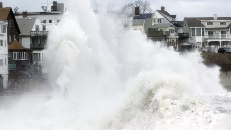
A large wave crashes into a seawall in Winthrop, Massachusetts, a day after a nor'easter in 2018.
AP Photo/Michael Dwyer
Floods are already the most common and among the most deadly disasters in the United States. As global warming continues to exacerbate sea level rise and extreme weather, flood-prone areas around the country are expected to grow by nearly half in just this century. Here’s how climate change plays a role in flooding and how we can better keep our heads above water.
Flooding facts and causes
What causes a flood?
A flood, put simply, is the accumulation of water over normally dry land. It’s typically caused by the overflow of coastal or inland waters (like rivers and streams) or by an unusual accumulation of water from heavy or prolonged rains, storm surges, or sudden snowmelt. Often, the ways in which we manage our waterways (via dams, levees, and reservoirs) and the alterations we make to land also play a role in flooding. Increased urbanization, for example, adds impermeable surfaces (think roads and parking lots), altering natural drainage systems. Areas can be especially prone to flooding when stormwater infrastructure isn’t maintained or homes are built in areas susceptible to flooding known as floodplains. More and more, flooding factors are also linked to climate change.
Major types of floods
River flooding
This occurs when a river or stream overflows its natural banks and inundates normally dry land. Most common in early spring, river flooding can result from heavy rainfall, rapidly melting snow, or ice jams. According to the 2018 study "Estimates of Present and Future Flood Risk in the Conterminous United States," published in the journal Environmental Research Letters, more than 40 million U.S. residents are at risk from flooding along rivers and streams. And even a single episode can wreak havoc on a massive scale: For instance, in 2019, a slow-motion disaster of intense spring flooding swelled the Arkansas, Mississippi, and Missouri rivers. Hundreds of miles of levees were topped or impaired, destroying homes and supersaturating cropland. According to the National Oceanic and Atmospheric Administration (NOAA), the inland flooding caused $20 billion in damage. Some of these losses stemmed from the impact to farmers who could no longer plant or transport their crops.
Coastal flooding
More than half of the U.S. population lives or works in areas susceptible to coastal flooding, which happens when winds from a coastal storm, such as a hurricane or nor’easter, push a storm surge (essentially, a wall of water) from the ocean onto land. A storm surge can produce widespread devastation, like that seen around New York and New Jersey when Hurricane Sandy arrived during high tide.
There are also increasing numbers of shallow, nondeadly floods caused by higher sea levels. These high tide floods (also known as “nuisance” or “sunny day” floods) occur when the sea washes up and over roads and into storm drains as the daily tides roll in. In places like Miami, increased nuisance flooding is raising concerns over climate gentrification, as wealthier residents looking to settle on higher ground are pricing out historically underserved BIPOC communities.
Flash floods
These quick-rising floods are most often caused by heavy rains over a short period—usually six hours or less. Flash floods can happen anywhere, and low-lying areas with poor drainage are particularly vulnerable. Also caused by dam or levee breaks or the sudden overflow of water due to a debris or ice jam, flash floods combine the innate hazards of a flood with speed and unpredictability. That’s why they’re responsible for the greatest number of flood-related fatalities. In late 2022 and early 2023, California was hit by deadly flash floods during powerful wintertime atmospheric rivers, which may become more powerful as climate change increases the amount of moisture they can hold.
Urban flooding
The term urban flooding refers specifically to flooding that occurs when rainfall—not an overflowing body of water—overwhelms the stormwater drainage capacity of a densely populated area. In 2021, Hurricane Ida, strengthened by warm air, shattered records across the Northeast. In New York City, the deluge made rivers of impermeable streets and subway stations. Eleven people living in basement-level apartments drowned as the floodwaters—with nowhere else to go—swiftly overwhelmed below-ground spaces.
Climate change and flooding
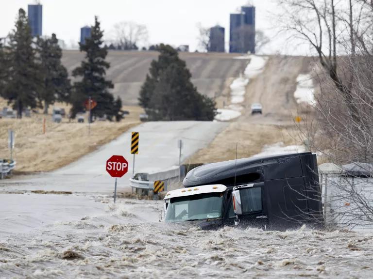
A tractor trailer is swept off the road by floodwaters in Nebraska in 2019.
Ryan Soderlin/Omaha World-Herald via AP
The Intergovernmental Panel on Climate Change (IPCC) has found that climate change “has detectably influenced” several of the variables that contribute to floods, such as rainfall and snowmelt. In other words, while our warming world may not be the only or most direct cause of any given flood, it exacerbates many of the factors that increase flood risk. That’s why mitigating climate change—and particularly, limiting global average temperature rise to within 1.5 degrees Celsius in this century—is an important way to avert some of the worst scenarios for sea level rise and escalating flood risks.
How does climate change lead to flooding?
These are some of the key ways that climate change increases flood risks.
Heavier precipitation
A warmer atmosphere holds—and subsequently dumps—more water. As the planet has warmed by 1.9 degrees Fahrenheit since the preindustrial revolution era, the United States has also become about 4 percent wetter, according to the federal Climate Science Special Report. The same report says that heavy precipitation events are projected to increase by 50 percent to as much as three times the historical average in just this century. This includes extreme weather like atmospheric rivers, which are air currents that become heavy with water from the tropics. Meanwhile, in regions with significant seasonal snowmelt, hotter temperatures can trigger more rain-on-snow events, with warm rains inducing faster and earlier melting—a phenomenon playing out in the western United States.
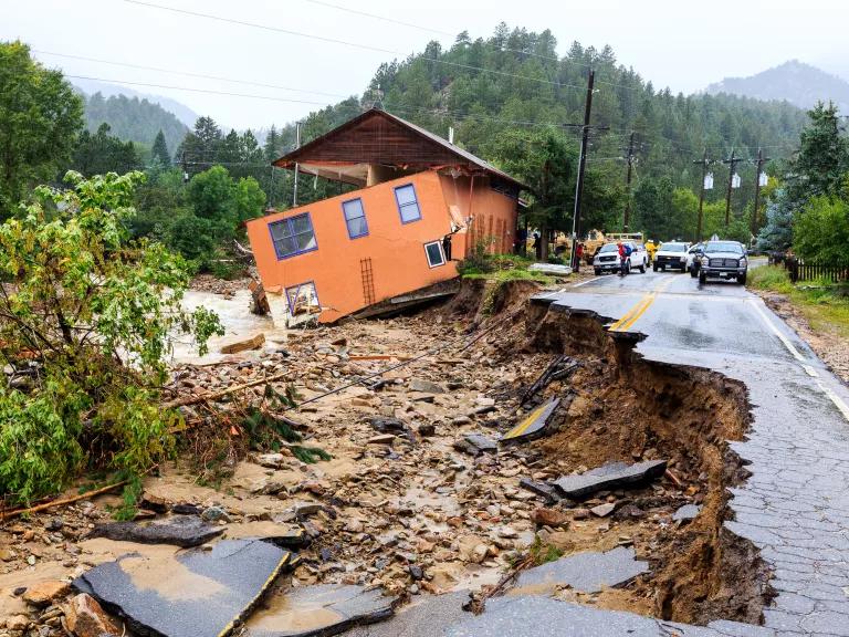
A building and road severely damaged by flooding in Jamestown, Colorado, in 2013
Steve Zumwalt/FEMA
More-frequent hurricanes
Climate change is increasing the frequency of our strongest storms, which bring greater rains, including in places not known for flooding. In August 2023, Tropical Storm Hilary—the first storm of its kind to hit the West Coast in 84 years—broke rainfall records in Idaho, Montana, Nevada, and Oregon. Hurricane Harvey, which made landfall as a Category 4 storm in 2017 and soaked Houston homes and businesses with catastrophic floods, was the nation’s wettest storm in nearly 70 years. Researchers estimate that Hurricane Harvey dumped as much as 38 percent more rain than it would have without climate change. Just a month after Harvey, Hurricane Maria hit Dominica, Puerto Rico, and the U.S. Virgin Islands. The storm produced the most rainfall in the area of any weather event since 1956 and exposed the inadequacy of U.S. policies to respond to disasters.
According to the IPCC, future hurricanes are expected to be as much as 37 percent wetter near their centers and about 20 percent wetter as much as 60 miles away. In the Atlantic basin, an 80 percent increase in the frequency of Category 4 and 5 hurricanes (the most destructive) is expected over the next 80 years. And it’s not only the most severely rated storms that bring the greatest flood impacts; in fact, the rating system the government uses to categorize the severity of storms is based solely on wind speed, not rainfall—so even unrated storms can unleash lethal amounts of water.
That said, gustier winds can whip up greater storm surges, which are already higher because of sea level rise. It was Hurricane Katrina’s 28-foot storm surge that overwhelmed the levees around New Orleans in 2005. Winds can also increase the destructiveness of waves, causing storm surges to get bigger and penetrate further inland.
Higher seas
As ocean temperatures rise and the glaciers and ice sheets melt, global sea levels are rising—and directly contributing to coastal flooding problems. According to the Fourth National Climate Assessment, our oceans are approximately seven to eight inches higher than they were in 1900. The IPCC predicts seas around the world will rise anywhere from just under one foot to more than three and a half feet above 2000 levels by century’s end. NOAA’s projections also show that, due to regional factors such as currents bringing water to coastlines, areas along the East Coast could experience seas rising 2 feet higher as early as 2050. By then, damaging coastal flooding is expected to occur 10 times as often as it does today.
In addition to amplifying storm surges, sea level rise increases high tide flooding, which, according to NOAA, has doubled in the United States over the past 30 years. For example, by 2045, Charleston, South Carolina, could see as many as 180 tidal floods per year, compared with just 11 in 2014.
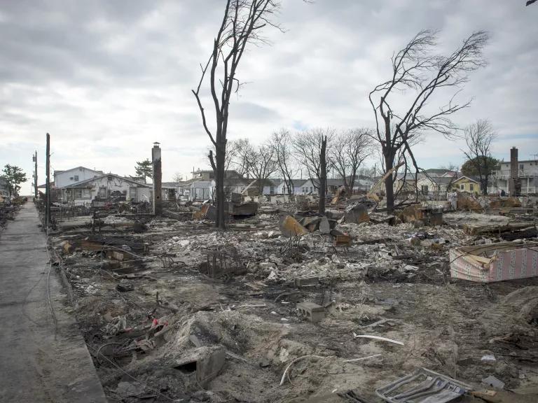
More than 100 houses burned down in Breezy Point, New York, as floodwaters isolated the community from fire and rescue workers after Hurricane Sandy.
U.S. Navy photo by Chief Mass Communication Specialist Ryan J. Courtade/Released
Consequences of flooding
When flooding inundates a home or community, it upends lives. It’s important to consider flood preparation before disaster hits by doing things like signing up for alerts, packing an emergency supply kit, and researching flood insurance options.
But the impacts of flooding go far beyond our own homes. Repairing and replacing flood-damaged roads, bridges, utilities, and other public infrastructure carry enormous costs. Between 2007 and 2017, the National Flood Insurance Program (NFIP) paid an average of $2.9 billion per year to cover flood-related losses, with individual years often costing far more. Within two months of Hurricane Ian making landfall in Florida in 2022, the NFIP had received 44,000 flood claims from property owners. These types of estimates leave out the many people who don’t have insurance, who aren’t eligible for government disaster assistance, or who have needs above what government aid will cover.
Flooding also brings contamination and disease. Floodwaters can carry raw sewage, leaked toxic chemicals, and runoff from hazardous waste sites and factory farms. They can pollute drinking water supplies and cause eye, ear, skin, and gastrointestinal infections. When floodwaters recede, bacteria and mold may remain, and residents may suffer from mental health problems and lost business or wages.
As with many natural hazards, it is most often lower-income people, people experiencing homelessness, the elderly, and communities of color who suffer the greatest harm. These populations are least likely to have flood insurance, access to transportation during an evacuation, cash on hand, or the ability to relocate—and the structural inequities of the past and present mean they are more likely to be in harm’s way. In August 2022, flash flooding in Jackson, Mississippi, caused the city’s main water treatment plant to fail, leaving the 150,000 residents of the majority-Black city without safe water to drink, bathe in, or cook with. In the case of Jackson and many U.S. cities with similarly outdated infrastructure, flood damage was exacerbated by existing issues, including poor oversight, lack of local resources and capacity, and other unjust racial and economic disparities.
Flood preparation and prevention
Entirely preventing floods isn’t possible. But there are steps that can be taken to lessen their devastation, like flood-proofing your home, taking personal safety precautions, and advocating the federal government to revamp its approaches to flooding, both before and after it occurs.
A neighborhood in Port Arthur, Texas, flooded by Hurricane Harvey in 2017
Staff Sgt. Daniel J. Martinez/U.S. Air National Guard
Updating FEMA's flood maps
Mitigating potential loss from future floods requires knowing where floods are most likely to occur. In the United States, this information is provided by FEMA, which produces maps of the nation’s flood zones. Its NFIP relies on these maps to assess flood risk, determine insurance rates, and establish floodplain management standards.
FEMA flood maps depict the high-, moderate-, and low-risk flood zones of communities nationwide and can be found at FEMA’s Flood Map Service Center. High-risk areas, often referred to as floodplains, are regions with a 1 percent (1 in 100) chance of being inundated by river or stream floodwaters of a certain magnitude in any given year. (The term 100-year flood refers to this, and does not mean a flood that’s expected to occur just once every 100 years.) But even a 1 in 100 chance of flooding each year equates to about a one in five chance that a home will flood at some point over the life of a 30-year mortgage. And FEMA’s moderate- to low-risk areas aren’t entirely safe from flooding, either: Properties in these areas still account for more than 20 percent of NFIP claims.
Flood risks change as land use and other factors change. That’s why keeping flood maps up-to-date is critical. But despite a requirement that FEMA reassess its maps every five years, nearly 60 percent are out of date—some, by decades. When Hurricane Sandy hit in 2012, for example, the flooding covered an area that was 65 percent larger than the flood-vulnerable area identified by FEMA maps.
FEMA’s maps also typically fail to take into account the effects of global warming, such as sea level rise. Instead, they rely on historical data to determine future flood hazard projections. This can cause officials to designate areas as being “safe” for development today, even when they are at risk of serious floods tomorrow. In 2021, NRDC and the Association of State Floodplain Managers jointly petitioned FEMA to update its standards to reflect the new climate reality. After all, FEMA is required under law to use the best available science in its maps and standards. Among the petition’s requests: all new or substantially improved structures must be elevated higher than the level of a 100-year flood; all new and revised NFIP floodplain maps must depict how the floodplain will change over time, especially concerning sea level rise; homeowners seeking to retrofit their homes for the new climate reality should have easier access to NFIP funding.
Among other things, FEMA’s floodplains determine how and where homes and other structures will be built, as well as who is required to purchase flood insurance. (Coverage is mandatory if you live in a floodplain and have a federally backed mortgage.) The problem is, once again, that many of FEMA’s mapped floodplains are inaccurate. For instance, during Hurricane Harvey, nearly three-quarters of Houston’s flood-damaged buildings sat outside of FEMA’s identified high-risk area. According to one NOAA analysis: Greater rainfall has made what used to be a 100-year flood event in Houston, by FEMA’s standards, more like a 25-year event.
Understanding your home's flood risk
Flooding is a factor in hundreds of billions of dollars of disaster-related property damage in the United States, with many homes being repeatedly damaged. Just one inch of flooding could cost the average homeowner $25,000 in damage. But typical homeowners’ and renters’ insurance fails to cover flooding and less than 4 percent of homeowners have flood coverage. That means the vast majority of Americans must take out loans or pay out of pocket to repair or replace damaged items.
Finding out if a property is flood-prone can also be difficult. Many states have no legal requirements that a seller disclose a property’s history of flood damage to a buyer or that a landlord tell a prospective renter. While potential homebuyers should look at FEMA’s flood history maps, there’s a more low-tech option: Introduce yourself to your prospective neighbors and ask them about flooding in the area.
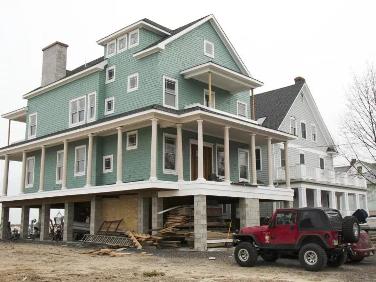
This Highlands, New Jersey, home was elevated prior to Hurricane Sandy and received only minor damage.
Rosanna Arias/FEMA
For residents of repeatedly flooded homes, relocation may be the best option. But a wide array of measures exist to prevent or reduce flood damage when that’s not possible. These include keeping gutters and drains free of debris; installing a sump pump for crawl spaces and basements; adding check valves in sewer lines to keep floodwater from backing up into the drains of your home; and safeguarding equipment by elevating furnaces, water heaters, electrical systems, generators, and air-conditioning units above flood levels. More drastic retrofits might be needed in areas with regular flooding, including raising the entire structure of a house.
Boosting local resilience
Flood resiliency can come from water-smart improvements to buildings and green infrastructure, restored wetlands and other natural barriers, updated FEMA maps that reflect new climate realities, and an overhaul of the NFIP to help more homeowners relocate to higher ground. One promising update is President Biden’s executive action to reinstate the Federal Flood Risk Management Standard, which includes commonsense measures such as requiring FEMA to rebuild flood-damaged public infrastructure like police stations, schools, and hospitals to be safer. (President Trump had scrapped the standard in 2017.)
According to a Pew poll, nearly 75 percent of U.S. voters support these measures. For one thing, they can save enormous amounts of money: For every $1 invested in riverine flood mitigation, taxpayers and the federal government save $7 in recovery costs. Moreover, such measures increase the odds that millions more people will stay safe—and dry.
In addition to securing your home, you can help secure your community. Checking in on your neighbors, sharing information, and determining how you might be able to help each other in an emergency are important components of disaster preparedness.
This story was originally published on April 19, 2019, and has been updated with new information and links.
This NRDC.org story is available for online republication by news media outlets or nonprofits under these conditions: The writer(s) must be credited with a byline; you must note prominently that the story was originally published by NRDC.org and link to the original; the story cannot be edited (beyond simple things such as grammar); you can’t resell the story in any form or grant republishing rights to other outlets; you can’t republish our material wholesale or automatically—you need to select stories individually; you can’t republish the photos or graphics on our site without specific permission; you should drop us a note to let us know when you’ve used one of our stories.
Mapping Urban Heat Islands Is Helping These Neighborhoods Adapt
What Are the Solutions to Climate Change?
What Is Climate Gentrification?